Tour of the Alps 2008by Jobst Brandt  Part I: San Francisco, San Francisco International (SFO)
Frankfurt, International (FRA)
Part II: Frankfurt, International (FRA)
Zurich (ZRH)W
|
On Wednesday, 09 July, I flew with Lufthansa from San Francisco via Frankfurt to Zurich, arriving Thursday afternoon 10 July. I was surprised that Lufthansa did not charge an extra baggage fee for my bicycle as most other airlines do these days. I took a train from the ZRH to Schwyz where my friends, the Dierauers, picked me up for the short ride to their house in Ibach, home of Victor Inox, aka Swiss Army Knife. Edith and Turi Dierauer have been my gracious hosts for many bike tours, as were the senior Dierauers before them.
I unpacked and assembled my bicycle from my Nashbar soft-bag, installing the cranks, turning the fork and bars to the front and installing the rear derailleur and chain. The airport baggage mashers managed to bend my steel bars a little but straightened them by hand.
I noticed that I had failed to tighten the Shimano freehub after building my rear wheel, even though I had already used it on a few long rides. The bicycle shop "across the street" fixed that instantly, having the required 10mm hex key, and knowing how to remove the axle and sprockets. The freehub bolt can only be tightened on a finished wheel, there bing no means by which the required torque can be achieved on a bare hub.
After a great dinner I got a good night's rest in preparation for getting on the road the next morning, jet lag and all.
1. Friday 11 July Ibach - Rosenlaui 102km 2776m
I headed out to the Gotthardstraße at the road junction where Victor Inox (Swiss Army Knives is located) and headed for Brunnen (435m) on the Vierwaldstättersee (aka Lake of Lucerne) where I took the south-east shore into canton Uri, home of William Tell. The weather was cool with a partly cloudy sky that looked like it could rain.
Canton Uri (William Tell country) at the head end of the lake is full of history, some of it so remote that it is based on myth and lore, as apparently the person Tell is, who is a composite of the spirit of resistance to the Austrian empire, the "Rütli Schwörer" as chronicled by Friedrich von Schiller.
http://en.wikipedia.org/wiki/William_Tell
http://www.schweizerseiten.ch/info/axenstrasse.htm
http://de.wikipedia.org/wiki/Bild:Johann_Heinrich_F%C3%BCssli_018.jpg
The Axenstrasse is hewn into the vertical granite walls above the lake, as it alternates between ledges and tunnels, a barrier that was only passable by boat in ancient times. Below the road, the Gotthard railway lies almost entirely in tunnels from Brunnen to Flüelen. Meanwhile, the motorway tunnels deep into the mountain for the entire stretch with no view of the Alps.
I passed the main construction site of the new 52 Km Gotthard railway tunnel in Erstfeld (472m) where the SBB has a small freight yard and locomotive maintenance halls, this being the base of the climb to the current Gotthard tunnel at Göschenen (1106m). The road, in contrast, begins its climb abruptly at Amsteg where a large SBB hydroelectric plant serves the north slope of the railway while a similar plant serves the south ramp at Piotta.
With most traffic on the motorway, the old Gotthard road has regained most of its charm as it climbs to Wassen (916m), noted for its church that stands on top of a knob in the center of this village so that it is seen from the railway three times as the trains gain elevation through looping tunnels.
I took a right turn at the level spot of the central plaza to head up the Susten pass that begins climbing into the "impassable" granite slot at the bottom of the Meiental through curved tunnels with a stone arch bridge spanning the gulch.
http://www.goyellow.de/map/?lon=8.59907&lat=46.70607&z=17&mt=aerial
The Susten Pass road climbs steadily up this valley, visible from the road for the entire 8% climb to the summit (2224m). This has always been the glacier highway of Switzerland with its many glacier covered peaks and finally the Steingletscher that one confronts after exiting the summit tunnel. This glacier seems not to have shrunk in recent times as it descends from the Sustenhorn (3420m), a great white cone rising above the steep Gadmental.
http://www.goyellow.de/map/?lon=8.42779&lat=46.71987&z=13&mt=aerial
I descended to Innertkirchen (625m) through curved bare rock tunnels along the north side of the spectacularly steep Gadmental. For scenic beauty, the cumulus clouds added excitement to the day but now they were closing in as I crossed the Aare river and climbed the Kirchet (pass) of four short traverses rising 140m between narrow hairpins to climb over the narrow Aareschlucht gorge, through which the Aare river leaves the Haslital to reach the Brienzersee.
http://www.goyellow.de/map/?lon=8.22467&lat=46.70566&z=14&mt=aerial
http://www.aareschlucht.ch/
Just beyond the Kirchet I turned off onto the Scheideggstrasse to Rosenlaui where one of the great Swiss glaciers lies behind a similar narrows in granite walls. As I passed the Reichenbachfall at hotel Zwirgi, I could imagine hearing the voices of Sherlock Holmes and Dr. Moriarty as they went over the falls in Conan Doyle's work.
The watering trough at the waterworks came in handy as usual because this road climbs steadily at an 8-10% grade. Although steep, this is a rewarding climb, leveling off just below the Rosenlaui Glacier with the backdrop of the magnificent Wetterhorn (3701m). I stopped at Hotel Rosenlaui (1330m) not worried about finding a room, the weather had been so wet and cold the last few weeks. I was greeted by Andreas and Christina Kehrli, the proprietors of the over 200 year old Hotel Rosenlaui. Having stayed here often, formerly with the senior Kehrlis, was not disappointed except for the weather as it began raining.
http://en.wikipedia.org/wiki/Reichenbach_Falls
http://www.paloaltobicycles.com/alps_photos/s38.html
http://www.rosenlaui.ch/
2. Saturday, 12 July (Rosenlaui - Gletsch) 90Km 1539m
After a good breakfast I surveyed the weather and gave it bad rating because it was still drizzling and showed no signs of letting up. I put on my parka over my long sleeved jersey and warm undershirt and headed back down the hill, not being in the mood to climb in the rain only to see nothing but fog instead of the Eiger at the top of the hill. Not even the Wetterhorn was visible.
From Innertkirchen I headed up the Grimsel pass in hopes of sunnier skies in the Rhone valley. The Grimsel is a moderate climb, not as steep as the ride to Grosse Scheidegg and today there was little traffic, most tourist having made the decision not to test the cold wet weather. I passed the many landmarks like the KWO hydro-power plants and cableways used to maintain these projects in winter.
Just above Handegg (1401m) and after the otherwise scenic cobble stone road in the granite wall, at the base of the first dam, I zipped up my parka and put up my hood that I closed so only my nose and eyes were exposed as the rains came. Not only that, but after the lake and up to the next dam to the Grimselsee, I got a mix of rain and snow.
http://www.caingram.info/Finsteraarhorn.htm
There was no snow or ice on the summit lake on the Grimsel Pass (2154m), where the road passes through a gap from which a panorama of the Rhone Glacier (source of the Rhone) and the Furka pass to the southeast, offers a grand panorama on a clear day. I was more concerned with descending to Gletsch (1759m) where I could catch a bus over the Furka.
http://www.paloaltobicycles.com/alps_photos/s67.html
Above, to the east, the Galenstock (3583m) and the gap of the Furka Pass make a fine backdrop for the Rhone Glacier and the adjacent Hotel Belvedere.
http://www.paloaltobicycles.com/alps_photos/s55.html
http://mikeaz.free.fr/dfb/dfb2.htm
In Gletsch, I did a brief tour of the DFB (Dampfbahn Furka Bergstrecke) Furka Steam Railway train station, where a train full of tourists was getting ready to depart as their steam locomotive was being turned on the armstrong turn table for the return run through the Furka tunnel whose upper end lies at about the same elevation as the Grimsel summit.
It rained so hard that the passengers waiting for the Postauto (bus) stood on the top of the waiting-bench to get out of the splash of the rain in front of the covered bus stop. When the bus arrived, I hung my bicycle by its front wheel on the empty 6-bicycle rack on the back of the bus and took a seat next to the driver. It occurred to me that such a bicycle rack on the back of a bus would never work in the USA, considering that it was not observable from within the bus and that the weight of the entire bicycle hung from the front quick release wheel.
The Furka Pass (2431m), 267m higher than the Grimsel, lies in the gap at the head of this valley that is swept clean by avalanches, except for some shrubs. The Furka has a great panorama that, as I experienced once on an exceptionally clear day, can include the Matterhorn to the west. As the bus passed the curio shops and grand Hotel Belvedere, I could see the west portal Furka Railway 1874m long summit tunnel built in 1925 far below at 2016m elevation.
http://www.picswiss.ch/06-VS/s-VS-06/sVS-64-02.html
The road from here to Realp at in the Reuss valley is narrower, more like in olden times when it was unpaved, so driving a postal buss takes great skill in passing oncoming cars. The last resort is the famed three tone postal bugle horn of these buses that has the effect of an emergency vehicle siren in the USA. Other traffic must stop and yield the road, even to the extent of backing up to a wider spot. The driver can issue traffic tickets to non conformists.
These buses are designed with a short wheelbase for mountain curves, which means that the driver (and I) were sometimes out over the verge of the road on tight turns. Meanwhile I noticed that my, otherwise water resistant watch that I wear when swimming, had fogged up from riding drenched while descending to higher atmospheric pressure down the Grimsel. East of the broad top summit a long gradual descent passes Tiefenbach (2106m) where the grade gets steeper and the curves tighter on the way down to Realp (1538m) in the upper Reuss valley.
From here its a straight run on a wide road to Hospental (1452m) with the rain still coming down from a low cloud cover, which the driver told me was snowing on the Gotthard. I retired to Hotel Rössli, my usual overnight on these rides, and got a good night's rest after a hearty dinner.
3. Sunday 13 July (Hospental - Hospental) 0Km 0m
The trouble was that in the morning the weather was even worse, so I stayed in bed and hoped for improvement that didn't come, so I decided to take the bus over the Gotthard the next day, remembering how the south side of the Gotthard was often sunny and warm while the north side was cold and wet.
4. Monday 14 July (Bellinzona - Biella) 179Km 430m
Although it wasn't raining hard, I stood in a continuous drizzle at the bus stop for what seemed forever because I got there just after having missed the earlier bus. The Gotthard is as modern a mountain pass today as you can find in the Alps, so the comfortably heated bus cruised over the top in good time windshield wipers going full blast. There was practically no traffic, the tourist having stayed away for good reason and business traffic passing below in the Autostrada tunnel.
In Airolo the bus sops at the SBB train station and I decided that I didn't take the bus to descend in rain to Biasca and Bellinzona, so I took the train to Bellinzona where the roads were dry. From here its a short ride down to Lago Maggiore and the Italian border, where I rode down the east shore to Laveno remembering the great adventures of rides years ago.
I stopped in Luino at an ATM where on the past I got Lire but now it was Euros. After a few tunnels and climbing over a ridge I rolled to the ferry dock in Laveno just in time to be the first on board. The sun was out and the still and cool air perfect for bicycling. After landing in Verbania, I headed west up the Toce river to Gravellona and Omegna.
The weather was pleasantly cool as I rode along the lago Maggiore stopping in Luino, at the bank where I formerly got Lira from the ATM but the same machine now gives Euros. After climbing the only hill at Castelveccana, I descended to Laveno, arriving just in time for the ferry across the lake to Verbania. Lago Maggiore is a beautifully scenic route with pleasantly warm (drinking) water and places to swim. From Verbania I took the main road up the Toce river to Gravellona where I headed south to Omegna (298m) at the north end of Lago d'Orta. Omegna is a former steel town whose mills filled the valley to Gravellona. The rusting hulks have all been dismantled leaving a beautiful countryside.
http://www.lagomaggiore.net/old/uk/citta/omegna.asp
I rode along the east shore of Lago d'Orta with a picturesque island,
(the west side climbs hills) to Gozzano where I turned west up a short steep climb to Pogno and on to Borgosesia. After Pogno, the road climbs gradually through a chestnut forest passing empty former silk and wool textile mills. The road climbs along a small stream through a chestnut forest to summit tunnel at Restiglione (598m) after which it descends to Borgosesia (359m) on the Sesia river. The river had still not been restored to its former deep green splendor after the great floods a couple of years ago that destroyed the dam below town.
I felt I was back in good favor with the weather as I continued to Biella (420m) where I stopped at Hotel Colibri where I had stayed before. The hotel has only a breakfast room but no dinner service, so meal tickets are issued for a good restaurant around the corner.
5. Tuesday 15 July (Biella - Robilante) 42Km 280m
Next morning I called my friend Brian Tomlin in Ivrea (a few Km's to the west) who offered to drive over and pick me up for lunch in Ivrea. I got to know Brian on rec.bicycles a while ago, and got him to join me on a trip in the Alps when I passed through Ivrea a few years back. Since then he's become a good amateur racer while keeping busy as an EE in Ivrea.
After a light lunch, I took the train across the west edge of the Po valley, past Torino, and on to Cuneo (587m), where I got a traditional drink from the huge fountain in front of the train station before riding west to Borgo San Dalmazzo (541m) where I turned south along the Vermenagna river to Robilante (686m) and the Ristorante-Albergo Aquila Riale where I have stopped often.
6. Wednesday 16 July (Robilante - Arvieux) 142km 2804m
I was surprised that riding back to Borgo San Dalmazzo was farther than I thought, but flat, so it was a pleasant warm-up before heading west to the Colle de Maddalena (Col de Larche 1995m), a pass of which I had only seen the uninteresting approaches, passing it on either end. Once away from the "city" I was pleasantly surprised at the beautiful landscape and varied gradients that made this a pleasant discovery.
I took this route because I was concerned about getting stuck in more rain that was hovering on all sides and could interfere with my desire to see the Route des Grand Alps again. The Col de Larche descends close to Condamine (1300m), a gap with huge WWI and WWII fortifications. Here I joined the Col de Vars (2111m), that has been standard on my usual route farther south. The Vars has some quirky steep spots caused by "moving acres" in a huge slide area, but overall it's an easy climb.
After descending to Guillestre (1000m) I headed east up the Combe de Queyras along the Guil river that, as usual, was full of white water kayakers. I continued up to Arvieux (1544m) where I found good lodging and food.
7. Thursday 17 July (Arvieux - Lanslevillard) 144Km 2004m
After Arvieux (1544m) and Brunnisard the Col d'Izoard gets steep on its way through a thin forest to a false summit. From that summit the Obelisk at the real summit and the entire road leading there through a desert of grey scree is visible.
After a picture at the Izoard summit (2360m) with rain clouds chasing, I headed down to Briançon and up the long gradual climb to the Lautaret (2058m) where I dropped in to say hello to the Bonnabels of Hotel des Glaciers and head off to the Galibier, although neither Paul nor his nephew Domenic were home. Traffic was lighter than usual, probably due to poor weather and economy, but my bicycle didn't need any of that expensive fuel from ESSO.
With low traffic, I had no problem violating the "No Bicycle" rule for the Galibier summit tunnel (2505m) after which the descent is gradual before a short steep part into Valloire (1430m), after which a 5km climb to the Télégraphe (1570m) begins. From the Télégraphe it's a steep winding descent through a pine forest to the Arc river at St. Michel du Maurienne (711m).
Because today, most traffic takes the autoroute, Rt N6 was as quiet as it was more than 40 years ago. At Modane (1057m), the double track railway heads to Torino through the Frejus tunnel (built in 1871) and the autoroute begins its climb to a 12.9km tunnel leaving me on a sparsely used Rt N6 to Lanslebourg (1400m) and Lanslevillard where I stopped for the night.
8. Friday 18 July (Lanslevillard - Aosta) 160Km 2848m
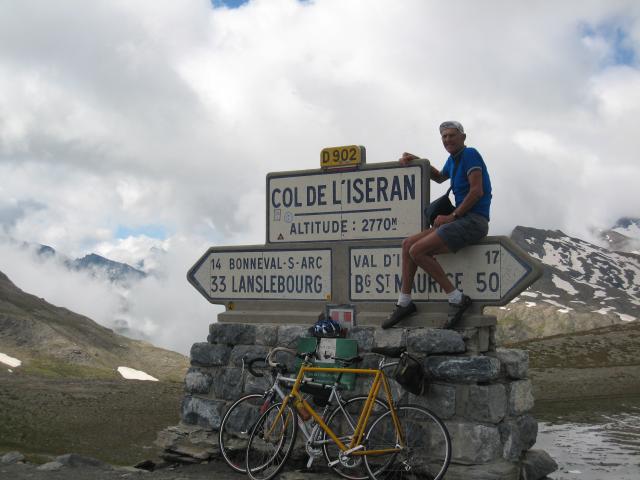
The day started well with only scattered clouds in an otherwise blue sky over peaks with fresh snow as I headed up the small climb Col du Madeleine (1677m) to the upper Arc river to Bonneval sur Arc (1835m). The Iseran pass starts climbing at Bonneval in three stages, the first makes two long straight traverses of the north wall of the Arc valley, after which heads into a narrower fairly flat valley before looping around to climb above a waterfall at the upper end of that valley from which a magnificent view to the south opens through the gap that leads to the summit.
I was climbing in clear weather and pleasant temperature and got the classic summit picture taken of me sitting on the large summit sign at the top. The descent to Val d'Isčre (1840m) is fairly straight and well paved although in town underground utility construction keeps the main street rough. At the end of town a short tunnel climbs out of the flat area that is now entirely built up into a ski town.
Descending through a series of tunnels I reached the dam at Lac du Chevril (2000m). A few steep runs passed through Sainte Foy Trentaise (1051m), where a road to the Petite St Bernard cuts off just above a steep sweeping turn in town. Although it looks like a shortcut on the map, it is not because it winds around while it climbs steeply through the hills. At the junction of Rt D902 and Rt N90 to the Col du Petite St Bernard and Aosta. In Seez (920m) I headed east toward Aosta.
Once again I appreciated the pleasant climb to the Petite St. Bernard from Seez rather than the "shortcut" at St. Foy that I had tried once thinking that descending to Seez was extra work... but it isn't. Col du Petite St Bernard (2188m) with its statue on a rock outcropping next to a small church is a scenic climb with a pleasant gradient on either side.
http://commons.wikimedia.org/wiki/Image:Petitsaintbernard01.jpeg
I descended to Pré St. Didier (1017m) on N26 where I joined the Mont Blanc tunnel road on its way to Aosta (583m) and turned north up the Pso del Grande San Bernardo (2473m). Interestingly Val d' Aosta is a French speaking region of Italy but most road signs are in Italian. I had an inquiringly beautiful sunny day with billowing white clouds, here and there.
9. Saturday 19 July (Aosta - Brig-Ried) 164Km 2255m
Under fine weather, I headed up the Grande San Bernardo (2473m) with light puffs of clouds over the highest peaks. A few kilometers below the summit, the autostrada heads off to a new alignment and heads for its summit tunnel, leaving an even more deserted road for me.
I got my traditional picture taken in front of one of the last concrete Swissroad sign at the summit in front of the curio shop window full of toy St. Bernard dogs. Meanwhile, most traffic was on the Autostrada in the tunnel under the summit.
http://www.roberts-1.com/t/b06/ch/k/c/index.htm
I recall when this was an unpaved road but now I'm glad to join the tunnel traffic on a smooth road to Martigny (617m) in the Rhone valley where I caught the afternoon wind up the valley to Brig (684m). The valley is mostly vineyards but also fruit orchards. To reduce evaporation, most of the agricultural land is covered with a layer of flat river bottom rocks, while some orchards were covered with netting to prevent hail damage.
Although nearly flat, this is a beautifully scenic run up the Rhone valley to brig, especially with the usual tailwind. From Brig I headed up the Simplon pass stopping in Brig-Ried, a small town up the road a short distance from town.
10. Sunday 20 July (Brig-Ried - Cama) 151Km 2112m
After a buffet breakfast I headed up the hill, joining the Simplon highway again after the bridge that bypasses the town and has a no-bicycles sign that I have always ignored but didn't need to today. A moderate grade up this wide highway rises to the Schallberg tunnel that rounds the corner into the Gantertal (1840m), above the Saltina river. As in the past several years, the concrete covered suspension bridge was still under repair construction.
http://www.panoramio.com/photo/4054222
as it is in the picture. All uphill traffic is detoured on the old road that makes a long U-turn on a small stone arch bridge at the end of the valley. I haven't used that road in 50 years and didn't do it this time, because traffic could pass a bicyclist easily on the open lane.
Above Berisal (1524m), I was back in the Saltina valley with the road following to the east wall, ducking in and out of tunnels and completely glass brick enclosed avalanche sheds. The Simplon Pass (2005m) is an all year highway and is covered in the hazardous areas. From the Simplon (2005m) the Eiger and a bit of the Aletsch glacier are visible in the panorama to the north and to the south, the monastery and ancient hotel occupy the marshy meadow along the Chrummbach to the south.
After the short flatland, the road enters the Gondo canyon clinging to sheer granite walls of the upper Val Divedro revealing Gabi (1228m) about 300m directly below. A short way down to Iselle (673m) the south portal of the Simplon Railway tunnel exposes the tracks for a moment before they duck back into a tunnel that takes them to Varzo (532m).
Varzo was once a great top gear sprint challenge up to the crest in town because it was straight 500m with a 65kmh coasting approach. Today an elevated bypass skirts the town with its narrow street, a project that took about five years to build. As I cruised down past Varzo I got a mysterious slow leak in the rear tire. I didn't want to get into tube patching so I grabbed my pump and noticed that the airport baggage mashers had broken off the handle of my old Silca Impero plastic pump that served me for many years.
Pushing on the stub end of the 10mm diameter piston tube, I was able to get enough air into the tire to continue down to my favorite bridge just above Crevola d'Ossola where the new road enters a tunnel.
http://www.paloaltobicycles.com/alps_photos/i08.html
It's a short drop into the valley across to Masera (297m) from Crevola d'Ossola. Masera lies at the bottom of the climb to Druogno (831m) in the Valle Vigezzo on the way to Locarno back in Switzerland. This is also the route of the scenic meter gauge Centovalli railway that runs between Locarno and Domodossola.
The blue and white train full of tourists passed me as I climbed to along the Melexxa river to Druogno (831m) from where the Val Vigezzo descends gradually to Locarno (200m) on Lago Maggiore. Traffic was light and a pleasant breeze made riding along the Plan di Magadino past Bellinzona easy.
At Arbedo (230m) on the Gotthard route, I turned up the Valle Mesolcina and stopped at a local grocery store with a bench in the sun to fix my slow leak tire. I picked this spot for the warm sunshine as much as the presence of a bicycle with a tire pump parked in front of the store. After removing a "Michelin wire" from the tire I installed my spare tube and got it well inflated with the borrowed pump.
Valle Mesolcina is flat for about 20km before climbing to Mesocco (790m) where the climb to the San Bernardino pass begins. I stopped in Cama (296m) for the day and slept well hoping for more good weather.
11. Monday 21 July (Cama - Casáccia) 124Km 3432m
A short bump got me up to Mesocco (790m) and because autostrada were built in the Alps long ago, many old cobblestone roads remain and are often well maintained in original condition and have little traffic. From Mesocco, the former terminus of an RhB line from Bellinzona, the road climbs to Pian San Giacomo (1140m) and then climbs to the town of San Bernardino (1607m) where the autostrada enters its tunnel while the old road climbs through a glorious landscape to the San Bernardino summit (2063m) with a summit lake next to an old monastery.
On the descent into the Hinterrhein valley I was surprised that the huge Swiss army artillery range was silent and deserted. The autoroute emerges from its tunnel here in Hinterrhein (1624m) and uses the right of way of old highway, but for local traffic a one lane frontage road was built to bridge the gap to Nufenen about a kilometer down the road, from which the old cobblestone road emerges to make a pleasant ride to Splügen (1460m), the turnoff to the Splügen pass.
Although the weather was cool and cloudy, it seemed to be a safe bet that it would be dry over the pass, unlike last year. Climbing in the cool air was more pleasant than descending the San Bernardino. The Swiss-Italian border lies on the summit (2117m) but with the EU, border stops are no longer required.
After Monte Spluga (1908m) and a large granite faced hydroelectric dam, the road enters a series of convoluted hairpin turns, in tunnels in the granite wall. There was almost no traffic, because many car drivers find this route terrifying. At Chiavenna (333m) I turned east toward St. Moritz crossing back into Switzerland and finished the day in Casáccia (1458m).
12. Tuesday 22 July (Casáccia - Ponte di Legno) 140Km 2636m
The morning sky didn't look good but after a good breakfast, I headed out and up, the Maloja pass being right in front of town. I was glad to get into th wall on which the hairpin turns wend their way up this one sided pass that has no downhill on the east side, it being an ancient glacial valley with three large lakes. The top of the Maloja pass (1817m) is in front of the Maloja hotel, continuing along the shore of the Silsersee, Silvaplanasee, and the St. Moritz lake.
Meanwhile, it wasn't warming up because the sun did not show through the clouds, so I rode to the St. Moritz train station with plans of bailing out, but there were no trains, so I headed down the hill into the Inn valley where I took hope as I saw a brighter sky to the south. The light drizzle had stopped as I rode through Pontresina (1805m) and headed up the Bernina pass.
I took a picture of the Morteratsch glacier with its upper end vanishing into clouds, from the Bellavista curve of the RhB RR but no train. A bit farther up, just past the Diavolezza aerial tram I got a shot of a red Bernina Express train heading up the pass ahead of me. I passed the summer dormant Lagalp aerial tram when it began snowing a fine granular snow that just blew around like sand, so I wasn't getting wet. My parka was doing a fine job and I was still climbing to the Bernina (2339m) keeping warm.
The descent is long and swift to Poschiavo (1021m) where it was a bit drier but still overcast, but I could see clear sky ahead as I got to lago di Poschiavo and the last steep part to Brusio (780m) and a good lunch at one of my favorites, Hotel Bottoni, where I was welcomed by the Betis who run the place. From here it's a short drop to Tirano (430m) in the Valtellina. I crossed the valley and crossed through Stazzona to the small woodsy road that makes a pleasant shortcut to the Passo Aprica (1175m).
Aprica is a pleasant lineal town in the gap of the mountains that gives the pass its name. From here its a long gradual descent to Édolo (690m) along the Oglio river. From Édolo I passed Monno (1067m), at the north end of the Mortirolo pass that, from my perception has no benefit other than being steep, narrow, and part of the Giro d'Italia, although it is a shortcut from Tirano to Ponte di Legno (1258m) the base of the Gavia pass. The afternoon was getting late as I stopped in a short visit with my good friend Silvano Macculotti's hotel, the Veduta Dell Adamello in Temú.
He invited me to stay, but being early enough to get closer to the Gavia pass I went on to stay just above Ponte di Legno at Hotel Frigidolfo after having ridden to the hotel at Apollonia (1415m), the start of the Gavia climb, that was recently remodeled and not open for guests.
13. Friday 23 July (Ponte di Legno - Riffian) 145Km 3008m
Although I arrived under threatening skies, the morning was beautiful and I got a good start up the grade after a drink of rusty fizz-water at Appolonia, a ritual I started years ago, once when I was truly thirsty and was surprised by the taste. On the way up some fast tourists passed me after we talked a bit. I noticed that ANAS, the highway department had erected a concrete snow deflecting wall across th upper end of "the cliff" that made even walking around impossible.
From here the summit is visible three kilometers farther up the road. Rifugio Bonetta on the Gavia (2621m) is an old stop and this time I met a bunch of riders who had all bought the postcard of me riding under the cliff in 1978 when the road was still unpaved. After autographing their postcards, Signor Benetta's son downloaded my 100 picture slide show from my memory stick. After downing the traditional refresher, I said goodbye and headed down to Bormio (1225m) and headed up the greatest road in the alps, the Stelvio.
http://tinyurl.com/5udpa4
http://tinyurl.com/567xfm
I could not have asked for better weather, no wind and cool air for climbing, so much so, that I had no great need for drinking on the climb other than a can of soda that I drank at the top of the Val Braulio, about half way up. On the Stelvio as on other occasions I rode right over the top into the view of the glacier covered Ortler (3899m) above the val di Trafoi with its endless hairpin turns.
Then I turned around, regained my composure from this overwhelming experience that brings back wonderful memories of many rides here. I got a Reuben sandwich from the vendor who recognized me as the young guy who stopped there fifty years ago. I still knew his claim to serve: "Die höchste Wurst in den Alpen". That and a Coke sent me down the hill to Prato, his home, and on to Spondigna (885m).
I cruised down route N38 to Merano (302m) and headed north up the Passeiertal to Riffian (597m) where I found an economical hotel with good food. It was a great day considering the poor weather I had up to this day. Crossing the Gavia and Stelvio, the great ones of the Alps was a great adventure.
14. Saturday 24 July (Riffian - Assling Tal) 175Km 2312
St. Leonard (688m) was a short distance up the road at the bas of the Jaufen pass (2099m) under sunny skies and balmy weather. The Jaufen pass is a gradual climb made of many esses through a pine forest and open meadows over which beautiful panoramas to the south are exposed. Other than lovely wildflowers and an impressively deep valley left behind, this pass is not a a match for the ones yesterday.
After a pleasant descent on dry pavement I turned south before reaching Sterzing (948m) down the Fortezza Francesco (749m) where I took the cutoff into the dolomites toward Brunico (835m) and Dobbiaco (1241m) on my way past the Dolomites, the weather to the south not looking good. I rode on into Austria and stopped in Sillian (1102m) in the Aue valley.
15. Friday 25 July (Assling Tal - Wald) 175Km 2312m
I was so glad to find a mostly sunny day ahead because that's what riding over the Großglockner takes. I headed out to Lienz (675m) and up the Iselsberg Pass (1204m) that connects the Drautal and the Mölltal in Winklern (840m) before the climb to Heiligenblut (1301m) at the base of the 33Km Großglockner climb.
The grocery store at the road junction in Heiligenblut was open as always in spite of former closing hour laws and the like because it is largely a tourist stop. I tanked up and got a candy bar (power) for the climb that starts in front of the store with a warning sign that the grade is 12% (in some sections). I was feeling good and know that there is a cafeteria style restaurant at Kasereck (1913m) before a slightly downhill section before the last assault that is mostly 12%, but with broad hairpin turns.
I got my picture taken at the Großglockner Hochtor (2505m), a 300m long tunnel, so that the north portal is visible behind me standing in the massive granite masonry portal (with typical Austrian religious symbols). I have told friends that "You ain't done yet" because the road descends steeply to Mitteltörl (2328m), the middle, summit that also has a tunnel, before descending a bit farther before climbing at 12% grade to Fuschertörl (2263m).
Fuschertörl sits on the rim of the enormously deep and steep Fuschertal, of grass and wildflowers with grazing Ibexes, on the other side of which are glacier covered peaks including the Großglockner (3798m) from which the road takes its name. A tour of about thirty Harley-Davidson riders were just starting the descent as I pushed off and found myself passing most of them after a few kilometers, however, on the straight sections they all came rolling by.
I passed then again at Fusch (807m) because bicycles are not required to pay toll on this toll road, so I could sail by at the bottom of the grade. I crossed the Salzach into Bruck (757m) and headed west up the Pinzgau past Mittersill where the 5.3Km Felbertauern auto tunnel at 1630m elevation, connects to Lienz.
I was dismayed that ÖBB, the Austrian State railway, could not make the Pinzgau 760mm (30") gauge railway profitable while the private Zillertal 760mm gauge railway, on the other side of the hill, is doing fine with freight and passenger traffic, and runs steam trains. So the tracks from Mittersill to Krimml were taken up. This may be the cause of this loss:
http://austrianswiss.fotopic.net/p1025272.html
At Wald, I took the old Gerlos pass to reach Hotel Grübl where Mrs. Kaiser presides and runs a great place. The new highway was built broad without 17% grades to blast away at high speed in any weather.
http://austrianswiss.fotopic.net/p1025272.html
16. Saturday 26 July (Wald - Unterperfuss) 145Km 750m
From Hotel Grübl, a 400m long section goes straight to the next plateau at a steady 17%, something common on old Austrian roads. Right after breakfast, this was an easy "Sprint" at maximum effort and worked as well as previous years. There are a couple of steep spots after that but they are short.
The old Gerlos (1486m) was wiped out by a huge hydro-electric reservoir that makes a pleasant reflecting pool for the alps to the south. I had the pleasure of riding up through that valley years ago, before the dam was built and the ski areas developed. Those were simpler times with practically no traffic, compared to today. At least the old road up from Wald is still that way but after descending the east slope to Gerlos (1245m) traffic picks up and there is only the old road.
Once down in the Zillertal at Zell (575m) it was smooth rolling with the Zillertalbahn puffing along next to the road. At Straß, I turned west toward Innsbruck on the south shore of the Inn.
http://tinyurl.com/59p592
http://tinyurl.com/6cx2b8
At Straß (523m) on the Inn river, I chose the main highway to Innsbruck, the Autobahn having taken most traffic. The weather was cool and sunny with billowing clouds as I passed Innsbruck (574m) and continued up the valley toward the Arlberg Pass, stopping in an oddly named town of Unterperfuss (below on foot) just across from its twin, Oberperfuss (above on foot) right next to Zirl at the base of the 18% grade Zirlerberg road.
17. Sunday 27 July (Unterperfuss - Linthal) 159Km 924m
I headed west, through the narrows of the Inn river at Pians and the junction of the Ötztaler Ache river that comes down from the Timmelsjoch Pass (2474m) from St. Leonhard above Merano in Italy. From here the road makes a gradual two kilometer climb before descending back to the Inn at Roppen aka. Bahnhof Imst where a bike path runs along the Inn river next to the Autobahn to Landeck (816m) where the Reschen pass heads south to the Stelvio and the Silvretta and Arlberg pass head east to Switzerland.
The weather was poor in all directions so I took the train from Landeck through the Arlberg tunnel, the line that was out of service for major track work last year. From Bludenz (581m) I got rolling, under cloudy skies, to Feldkirch (457m) where I turned south to Schaan in the Rhein valley and rode the Bike path on the east levee and got a good view of Schloss Vaduz looming over the valley like something from a Frankenstein horror movie.
http://www-pnp.physics.ox.ac.uk/~miyagawa/photo/travel/vaduz/
http://tinyurl.com/5bxke5
With the above map, zooming and panning, the course of this day is readily seen including the dark narrow wooden bridge over the Rhein.
I took the pedestrian/bicycle covered bridge across the Rhein to the west side levee and turned off at Trübach, cutting across to Sargans (510m). I found the bike path leading down to the Walensee from Mels but I have had trouble finding it on occasion. Looking at the lay of the land convinces me that, long ago, the Rhein flowed down this way to the Walensee and on to the Zurichsee instead of its current path through the Bodensee, because large levees keep it going north.
The bicycle path runs along the creek to Walenstadt (427m) on the Walensee where I rode to Mühlehorn and took the shortcut over the Kerenzerberg (700m) to Näfels (445m) in canton Glarus. I rode up the valley under increasing clouds past Glarus to Linthal (667m), the end of the SBB rail line, to find an appropriate hotel.
18. Monday 28 July (Linthal - Ibach) 74Km 528m
Here in Linthal, then end of the valley, the road cuts into the wall of the box canyon, and climbs to reach the high valley, Urnerboden, that belongs to Canton Uri that lies on the other side of the pass. Last year we just got to the only hotel just as a thunderstorm began dumping a downpour, but today it was bright and sunny with a lenticular cloud sweeping over the glaciers of the Tödi (3623m) and its neighboring peaks.
Although this is a beautifully scenic road, the Klausen Pass (1952m), is a grassy saddle with a summit hotel but nothing as striking as the climbs of the box canyons on either approach. The north approach clings to the north wall of the Schächental with a view of the valley floor practically like an aerial photo.
http://www.paloaltobicycles.com/alps_photos/s86.html
I rolled down to Urigen (1276m) to Steffan Truschner's rustic hotel in the hairpin turn and had a great lunch. Steffan and Karin run a great place above Unterschächen (996m).
Well nourished, I rolled on down the hill that has one more climb to get over the narrows of of the Schächental on the way to Altdorf and back along the Vierwaldstättersee on the Axenstrasse.
http://wanderland.myswitzerland.com/en/kultur_detail.cfm?id=319488
Although a bit shorter than I had planned, the ride went well without incident and mostly dry weather, although not as warm as I expected for the time of year.
2213Km 36500m climb.