Alpine Cycle Touring – A First Attempt
By Neil Critchley n.j.critchley@talk21.com
Satolas Airport was well sign posted from the hotel where I’d stayed overnight, a relatively luxurious break after so many nights camping. "Don’t go on the motorway" I kept telling myself as I cycled along busy roads and even joined minor roads using slip-roads. Soon though I pushed my loaded bike through the automatic doors at Terminal One, and apart from an air flight, train journey and a short ride home from Stoke-on-Trent Railway Station, the 7-week adventure was over.
The 7-week adventure had consisted of a solo cycle tour, which started in Chamonix and finished in Lyon visiting the Alpine regions of Switzerland, Austria, Italy and France.
This article covers my journey of almost 2200miles. It is written in sections, each encompassing several days cycling, usually between much needed rest days.
Introduction
Having cycled and mountain biked around my native Peak District for many years, I decided the time had come to venture further afield and to try my hand at cycle touring. I had both backpacked and cycled on many occasions, but never had I combined the two together.
Graduating from university gave me a sufficient opportunity, since I had a lengthy vacation to fill and the commencement of work later in the year would inhibit such a trip in the future.
Preparations were made, panniers purchased and on the 1st August 1998, I found myself heading for Chamonix. Transport was conveniently provided as I travelled by car with Simon and Helen, both friends from Sheffield University, who were going climbing in the Alps.
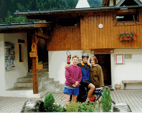
The beginning: pre-departure photographs in Chamonix.
Setting Off – on the Learning Curve
Monday, 3rd August 1998, after spending so many months talking about and planning my cycle tour, it was now time to conquer my first Alpine pass. It was an early afternoon start – just a short ride to get me to moving. The sun was slowly beginning to break through the thick cloud as we took pre-departure photographs and I cycled off towards Switzerland.
The road from Chamonix was fairly steep, but provided a good introduction as I soon reached the top of the Col des Mostets (1461m). Then it was downhill all the way to the Swiss border before my first proper climb to the Col de Forclaz (1526m), again this didn’t prove to be too bad as I then promptly enjoyed an exhilarating 20 minutes hurtling down to Martigny. The next few miles followed the River Rhone using a very busy main road – these weren’t the most exciting of miles, but necessary to get to the foot of the high passes that I would tackle over the subsequent days. However, since I was feeling fresh and excited, I decided to take several detours adding to the day’s distance and giving some much-needed uphill practice. I arrived in St. Maurice at a reasonable hour, 37miles completed and more importantly I was off the starting blocks.
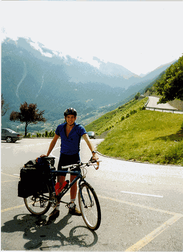
On the Col de Forclaz
My complacency about climbing these high passes was brought into order on my 2nd day, the Col de la Croix (1778m) was an absolute killer. I seemed to climb for hours on end through the thick cloud and mist which had been lingering for several days. Spurred on by the names of Pantani and Ullrich, daubed on the road I finally reached the top. This pass was very quiet and surrounded by thick woodland, quite a contrast to the fairly busy, but equally scenic, Col de Forclaz of yesterday. It was a very tired cyclist who reached Zweisimman later that day. I was now just part way up the learning curve, today’s lesson: ascending 2500m in a day on a bike is physically demanding.
The next day I reached Brienz, after a fantastic 73miles, I ascended the Grosse Scheidegg (1962m), which is a wonderful pass with a narrow winding road and virtually devoid of traffic, although the PostBus has priority and is as wide as the road! Fortunately, it was early evening when I descended down to Meiringen and the bus service had finished for the day. The downhill section was quite hair-raising since the road surface was poor – deep ruts, gravel and an assortment of potholes made for a bumpy ride. My mountain bike survived okay; however, two Dutch cyclists on racing bikes whom I’d met at the top had to push their bikes through certain sections to avoid buckling their wheels.
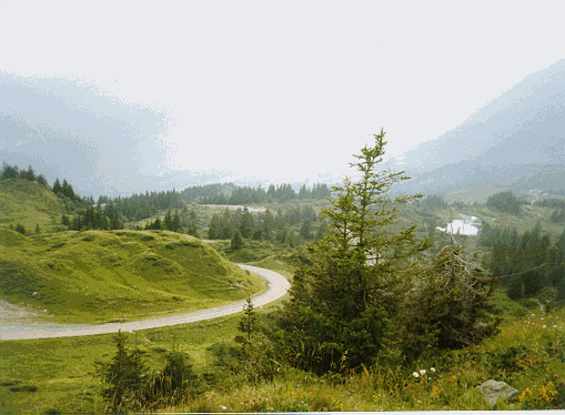
Looking towards Grindlewald from the Grosse Scheidegg
Camping on the shores of Brienzersee was pleasant, I was now in the high Alps of the Berner Oberland – I had a rest day before beginning my next stage and onto even higher passes.
The High Passes
The morning dawned fine, it was going to be a very hot day, the German cyclist whom I’d camped next to was bound for the Brunig pass, myself the Grimselpass and the Furkapass. I cycled past Meiringen and Innertkirchen before embarking on the long and extremely hot climb up the Grimselpass. I was overtaken by many other cyclists – albeit minus luggage as I slowly churned away for hours. Eventually I reached the top and all the effort was suddenly worthwhile – crystal clear skies revealing the glaciated peaks of the Berner Oberland. Near to the summit I met an elderly German man who’d just parked his car and was collecting some water. I thought it strange that he was wearing full cycling kit. He did speak to me, but he couldn’t speak English, nor I German. When I eventually got to the top, I saw him again with another elderly cyclist (who’d flown past me earlier on). I still couldn’t quite figure out what the arrangement was, until when I was descending the pass I saw the first German man cycling up the pass in the opposite direction – waving enthusiastically at me. Finally, the whole situation began to fit into place, obviously a one car – two bikes affair.
Next was the Furkapass, much quieter than the Grimsel, allowing me to really enjoy the surrounding scenery. It was a most enjoyable ascent with the road meeting the spectacular Rhone Glacier. At the summit, I caught up with three Swiss cycle-tourists who’d left Interlaken that morning – I didn’t meet many other cycle-tourists during my 7 weeks, so it was reassuring to learn that I wasn’t the only one.
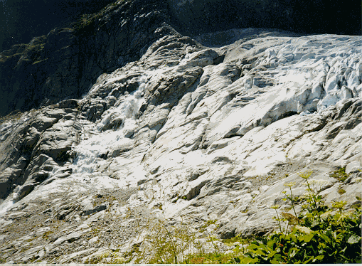
The Rhone glacier, seen from the Furkapass
My map led me to believe that there was a campsite in Andermatt, so I whizzed past the campsite in Realp. Upon arrival in Andermatt I discovered that the campsite had closed down several years ago, my enquiries were answered with "Try the one in Realp"! However, several camper-vans were parking up for the night on some rough ground next to the ski-lift centre. So, I pitched my tent alongside them, as I was unable to drive my pegs I had to leave the fly-sheet off and just hoped that it didn’t rain. Andermatt was very quiet, considering it was Friday – having had various pasta meals every night thus far I treated myself to a meal out – this fully charged my batteries for the days ahead.
Next was the Oberalpass, a very straight forward pass, which was followed by a long downhill interrupted by a few gentle climbs until arrival at Chur. The majority of the time was spent cycling on the sign-posted National Cycle Trails, which provide a great way of travelling through small Swiss villages whilst at the same time keeping away from the busy main roads. Be warned though – you end up climbing lots of hills but, without the worry of traffic, you hardly notice them.
In Chur, I got chatting an English couple who were camped next to me, I discovered that they were both from my home town of Stoke-on-Trent and that they also worked with a friend of mine. Small world! Crossing over the hills to the River Inn was hard work for two reasons: extremely high temperatures and a puncture which occurred at 1800m. Fixing the puncture was straightforward enough but inflating the inner tube using my frame pump was exceedingly hard work in the energy sapping heat. Finally 40psi was registered and I cycled over the Albulapass, amongst the most rugged and rocky mountain scenery I’d seen so far.
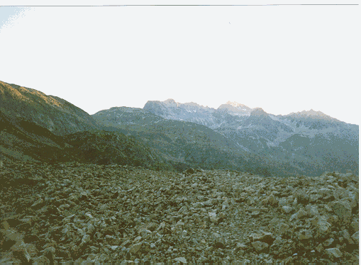
The ruggedness of the peaks surrounding the Albulapass
Into Austria
After a day in Scuol, it was just a short ride to the Austrian border and I passed through Pfunds. I then took a detour to get my first glimpse of the Tirol, it involved climbing high above the River Inn but the views from there made it more than worthwhile. The road then rejoined the River Inn and it wasn’t long before I arrived in Oetz. The campsite in Oetz was a very antiquated place, the dusty office and the ancient gardening tools left lying around gave the feeling that time hadn’t moved on in this particular spot.
The next day I climbed to my highest point in Austria, the Kuhtai pass (2017m). The ascent was the usual slow pedalling but the descent was sheer brilliance, fast with long straight sections with my speed approaching 50mph (80km/h). The Kuhtai is highly recommended, and a great alternative to following the Inn valley with its accompanying motorway and railway line. Soon, I was on the outskirts of Innsbruck and negotiated various junctions and one-way systems to reach the city centre. Just before the incoming thunderstorm, I made my way to a youth hostel, literally knocking on the door as the sky started to flash and the rain began to tumble. Unfortunately, the hostel didn’t open until 5:00pm, and I was forced to take shelter inside a folded up table-tennis table which had a tarpaulin cover – this kept me relatively dry as the storm raged on for half an hour. Eventually, the rain eased off and I made my way to another hostel.
Innsbruck was a nice place, although I found it very busy, probably from having spent almost two weeks in the peaceful high mountains. I departed for Zell am Ziller the following afternoon, a pleasant ride of 40miles along cycle tracks, putting me in a good position for tackling the Gerlospass the next day.
The Gerlospass and Pass Thurn on the way Kitzbuhl were both done under a very hot sun. Every single shop and supermarket that I passed in this region were closed, meaning that I couldn’t stock up on my much needed supply of bananas, I later learnt that this was due to an Austrian public holiday. I camped at St. Johann im Tirol, I managed to pitch my tent and cooked dinner just before the thunderstorm caught up with me again.
An easy, yet highly enjoyable day’s cycling took me to Salzburg. The final approach was the most interesting as the cycle tracks kept me away from any busy roads and then took me straight into the heart of the city, via a tunnel which cuts through the surrounding high cliffs delivering me to the front door of the famous Opera theatre. After a ride round the centre I made my way to the youth hostel.
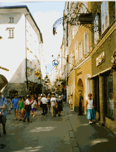
Salzburg’s busy main street
I spent a day in Salzburg, visiting the castle amongst other things. I also managed to impress all the Australians, New Zealanders, Americans and Britons in the youth hostel. The answer to the question "How are you travelling" is usually train or bus, my reply of "by bike, I’ve cycled here from Chamonix" was universally met with dropped jaws.
Rainy Days
My journey south through the Austrian Lake District to Lienz was a mostly wet affair. Several heavy storms did their best to hinder my progress, and even when it wasn’t raining it was generally dull. Sadly, I don’t think I saw this area at its best although as always it was still an enjoyable experience. At the end of my first day after leaving Salzburg, I arrived in Bad Aussee soaking wet; when I arrived at the local campsite I was delighted to be told that I could sleep in their wigwam! Complete with floorboards, benches and heavy duty tarpaulin, I had a dry and comfortable night in preparation for cycling over the Solkpass to Murau.
The thick clouds and mist hung closely to the peaceful forested roads, giving quite an eerie feeling at times. The rain continued, forcing me to seek shelter for quite some time one afternoon. One noteworthy incident was when I some how managed to take a right turn off the road I was following. It eventually turned into a rough track leading to a very remote farmhouse. Fortunately, I was able to rejoin the road by taking another track – great for mountain biking, not so good for arriving in Dobriach on time.
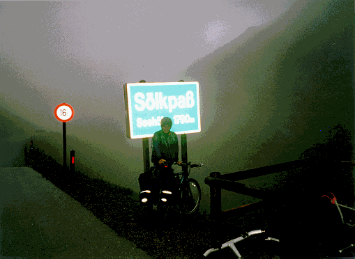
The Solkpass, near to Murau
My late arrival in Dobriach on Millstattersee, turned out quite well, as the campsite owner said I could stay in a caravan for the same price as pitching my tent! The ride to Lienz was fairly uneventful. The early morning was spent on minor roads crossing over mountain ridges to Hermagor. I then followed the Gail River for quite some time before crossing the hills back to the River Drau and into Lienz. However, today was to be significant since I had my first glimpses of the Dolomites – if the Austrian Dolomites were this good, then the Italian ones must be amazing!
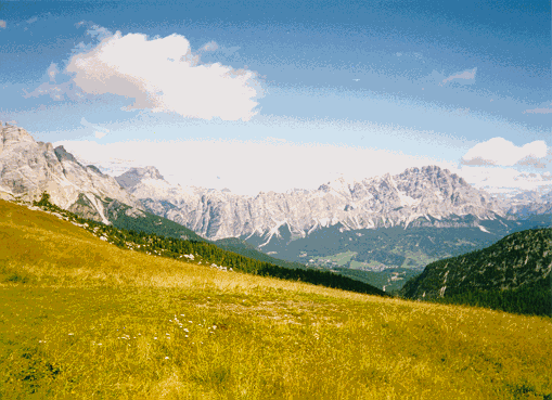
The Spectacular Italian Dolomites and Italian Lakes
My first day out of Austria and into Italy was a somewhat tiring affair, for some reason I just couldn’t propel my bike, it was as though my brakes were catching, I didn’t have enough energy, etc, – all psychological problems. Anyway, I managed to get to Cortina where heavy cloud hid the Dolomites.
I fell asleep listening to the rain, and hoping the campsite wouldn’t flood, since the ground was very hard and didn’t absorb rainwater. Awakening the next day I was greeted with brilliant sunshine and a warm spell which was to last several days. The sunshine reflected off steep sided cliffs as the Dolomites towered above me.
The following days were fantastic, my first Dolomiten pass was the Passo di Giau (2230m), which runs parallel to the Passo di Falzarego. I seemed to coast up the hill with minimal effort, every mile revealing something new. I then continued onto Predazzo via the Passo di Valles. The next day, it was uphill to the Passo di Costalunga the summit of which was a very busy place, lined with many shops, cafes and restaurants. The descent to Bolzano was also very good, with the lower sections passing through narrow and steep sided gorges.
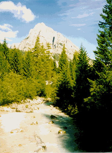
A taste of the Dolomites
The passage through Bolzano, however, was a little unnerving – very busy and very hot (it was my lowest altitude for 3 weeks). The miles to the bottom of the Passo di Mendola were quite dangerous – I could taste the pollution, but then all of a sudden I turned right, the traffic continued south and I had the Mendola almost to myself. This was a long climb, with 9 numbered switchbacks near the top. During the ascent I met a local Italian cyclist who, unlike most of his compatriots, didn’t zoom past me so I chatted to him every so often which meant the time passed quickly. Camping overnight in Sarnonico I met two Scottish lads in the campsite bar, they were travelling around southern Europe hoping to find some work fruit picking, although they kept arriving in places either before or just after the picking season!
Views from the Passo di Giau
Apple orchards lined my way, as the sun shone brightly, it was a good ride passing through very small Italian villages where the road would suddenly become so narrow – just allowing 1 car through at a time. I was slowly leaving the Dolomites and once over the Passo di Tonale, the Italian lakes were drawing near. I camped overnight in Edolo, the campsites were now suddenly very quiet as the high season had finished with the Italian schools re-opening. The advantage to me was a slight reduction in prices. After Edolo I ascended the Aprica pass, an easy climb, the road to Lago di Como was very busy, however, by taking detours and staying close to the river I was able to avoid the traffic. The valley sides were heavily terraced which in many ways ruined the visual environment. I much prefer the wild and untouched hills which I’d found frequently in the higher Alps. I camped in Gravedona, within sight of the lake, Gravedona boasts at least 10 campsites, all side by side and signposted from the main road – "Camping Italia ‘90" was tempting, but I chose the one with the poorest looking sign, hoping it would be the cheapest.
My next target was Lavena, a small village on Lago di Lugano, where my family would be arriving for a holiday the same day. Although, I only cycled 53miles it was to be one of the most eventful days of the whole trip.
I started relatively late, the lake side sceney was pleasant as I followed the Lago di Como shoreline. Upon reaching Menaggio I turned right and went over a few small hills to get to Lago Lugano. My final destination, Lavena, was on the south shore of Lugano – I decided to take the very quiet roads, climbing high above the lake shore and crossed into Switzerland for one short section. In the hot afternoon I reached Lanzo and then started the long descent back down to the lake. I passed out of Italy and into no-mans land – then to an event best described by my diary entry:
…a very steep and windy road – brakes not working quite as well as they should – a moments lack of concentration and bang I can’t stop in time, my arm scrapes along the wall, my front wheel takes most of the impact and I topple over to the left. I’m okay – a little shaken – I lift my bike up. Pushing is difficult something is catching. I go to the opposite side of the road, my brake block is under the rim. I manage to free it, I dab my bleeding arm with my handkerchief – just several friction burns and quite a few red patches. I put my chain back on, drink some water and set off again…
The remainder of the afternoon was performed at a fairly slow pace, reaching Lavena at 5:30 p.m. Confronted by a labyrinth of narrow roads, I was surprised to find 12 Via Ronconorini within moments. There was no reply when I rang the doorbell, so I cycled round to the back of the apartment building – which was directly accessible from the promenade along Lago Lugano. This is where I met 81 year old Madame Bonavia for the first time. With only a few words of French in common it took some explaining, with the aid of diagrams, to establish who I was and that I was here to meet my family.
It became quite confusing, since my family had not yet arrived and Madame Bonavia seemed to think that I was the Mr. Critchley (i.e. my father) who had booked the apartment. Eventually, the story became clear, followed by the exclaims of "Primadonna, mamma mia" when she heard how far I’d cycled. After a cup of tea, she noticed my wounded arm – which I was holding in the air to make sure I didn’t get any blood on the furmiture. The injury sprung her into action as she started sticking lint on it. By now it was past 6 o’clock and my parents were almost 3hours overdue. I decided that they must nearby, but due to lack of signposts and the maze of streets constituting Lavena it was quite possible that they just couldn’t find the apartment. So, I decided to have a cycle around to try and find them, after 10mins of aimless cycling I suddenly remembered that I could phone my Dad’s mobile phone. This meant returning to the apartment and a search through my panniers to find the number. I phoned them and discovered that they were running late due to hire car problems in Milan. Eventually, they arrived ending a comedy of errors.
My original intention was to have 2 or 3 days rest with my family, but a bed, food etc. pushed the break up to 5 days. It was an overcast Friday morning when I finally left. I took the path parallel with Lago Lugano to Ponte Tressa, then over a little hill to Luino and to the shoreline of Lago Maggoire – my 3rd Italian lake.
Which Way to France?
The route to France was a subject of much debate, I pondered maps for several days trying to decide the best way to get to France, and then where to go once I arrived. I decided to travel through the Valle D’Aosta, it would require one day of travelling along busy roads, but would deliver me to the heart of the French Alps and hopefully a few glimpses of the Mont Blanc massif.
One day out from Lavena I was climbing a gentle hill, just beyond Borgomannero, when I heard something snap and my back wheel suddenly stopped rotating. After a quick investigation I discovered one of the upright struts on my pannier rack was hard up against my back tyre. I removed my panniers and the whole rack came away in my hands – as all four struts had sheared from the two respective plates which keep them attached to my bike. Disaster? Fortunately I was able to use a spare pair of binding cords to secure the struts, they felt reasonably strong, but I was far from convinced. Whilst I tended to this problem, an incoming thunderstorm started to rumble with increasing intensity. As it was late afternoon I decided to return to Borgomannero to purchase some decent tape, and to find a campsite. Arrival in the town coincided with a very heavy rainstorm, I bought some tape and tie-wraps and immediately took shelter in a café as people hopped from doorway to doorway. I camped overnight near to Lago di Orta, and was kept awake most of the night by one of the longest and most intense thunderstorms I’d ever experienced.
The Valle D’Aoasta, was pleasant enough and I’m sure at one point it would have been a really nice valley with steep lightly wooded hills, old churches, the odd castle and superb glacial views at the French end. However, industry, terracing, roads etc. have removed the splendid charm other valleys have managed to maintain.
My last night in Italy was spent in La Thuille, part way up the Col du Petit St. Bernard, which gave me an opportunity to spend my remaining Italian Lira – a pizza did the trick!
My arrival in France was not anything spectacular, after two days of fine weather the rain decided to move in with a vengeance, making cycling virtually impossible. Every time I got ready to go a fresh storm would move in, it was after lunch before I finally got moving. The climbing was wet, and the many tourists I’d seen the day before were nowhere to be seen. The summit of the Col du Petit St. Bernard also marks the border between France and Italy and even in the rain and heavy cloud it was a fairly decent place to be!
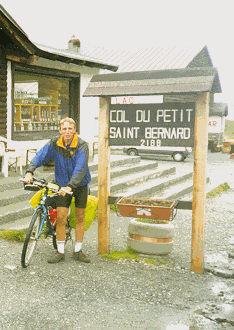
A damp, but happy cyclist on the French-Italian border
The downhill ride to Bourg St. Maurice was very cold, the wind ripped through my clothes. I was forced to keep my speed down, initially to reduce the wind chill effect but secondly, my fingers became so numb I just didn’t trust my braking responses!
South to the Gorge du Verdon
Departure from Bourg St Maurice heralded the start of a tough section of cycling, starting with the climb to Val d’Isere. I arrived around midday to find the place completely devoid of life. Lunch prepared me for the next 900m of ascent, the road ahead was brilliant with breathtaking scenery! A small souvenir shop, a church and a signpost were all that marked the Col de L’Iseran, (2770m) - the highest pass in Europe!
Reflections in Val d’Isere
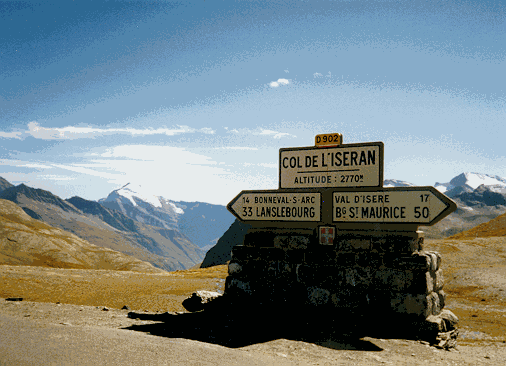
The Col de L’Iseran (2770m) – the highest pass in Europe
I ended the day at a small place called Orelle. The town clung to the steep mountain side and hosted a small camping/caravan site, where I was the only tent. The following day I tackled the Col du Galibier, slightly lower than the L’Iseran, but a far more demanding day out. To reach the Galibier, the Col du Telegraphie must first be ascended, at only 1500m it was not too bad, however the subsequent descent meant a tough and long climb to the summit of the Galibier. However, like many other passes, the summit held a reward far superior to the effort expended. The 4000m+ mountains of the Parc des Ecrins were revealed through the mist which was beginning to engulf the area. My arrival was greeted with applause from a couple of French families who’d driven up to the summit, I stood chatting with them for a while. This was a common feature whilst cycling in France as the locals greatly admire anyone who takes the time and trouble to cycle through their countryside. My blue bike loaded with panniers broke down many traditional barriers, and nationality no longer mattered.
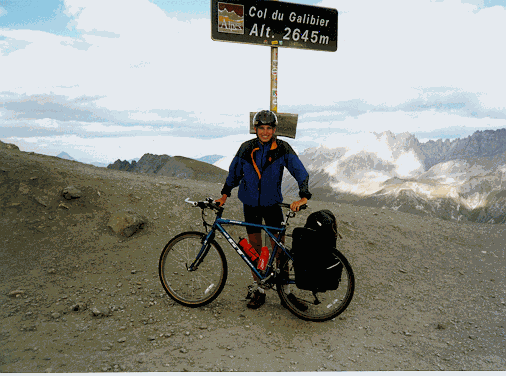
Smiles on the summit of the Col du Galibier
I soon reached the fortified town of Briancon, which according to the welcoming signposts has over 300 days of sunshine a year! The following day, Friday, was not one of these days. My ascent of the Col d’Izoard, a pass I’d been looking forward to due to its Tour de France connections, was a very cold and wet affair. I was very late setting off as I kept waiting and waiting for the rain to ease, just below the summit the rain became so torrential that I was forced to take shelter. Fortunately, the arrival of this latest torrent coincided with me passing the "Refuge du Napolean". My immediate words were "Une Cappuccino" as I stepped into the warm hotel. Lunch soon followed and almost two hours had passed before I was brave enough to enter the outdoors again (in addition, the food was so expensive I couldn’t afford to stay there much longer). A quick photo of the summit and I pushed on for Guilliestrie, getting completely drenched in the process. I’d only covered 30miles, but I was glad to be in my tent, even if the heavy rain kept me stranded in it.
The weather slowly cleared up the next morning, and despite been cold became quite clear and sunny. I noted on my ascent of the Col du Vars, that the surrounding peaks had received a light dusting of snow overnight – summer was rapidly drawing to a conclusion. The remainder of the day was spent battling against the wind and the long climb up to the Col d’Allos. The narrow road twisted and turned continuously, making it virtually impossible to see the route ahead. In fading light I reached the small town of Vercors, a delightful place with an old chateau marking its centre point. The cold snap persisted but it was a wonderful feeling when I sat in the entrance of my tent, feeling the heat from my stove as I brewed up. It was here that I met an English couple who had learned of my journey from the campsite owner. An invitation into their fantastically heated motorhome was gratefully accepted. They’d travelled extensively in France and the Alps gathering information on all manner of topics to use in talks and articles which they presented back home in Cornwall. After passing a pleasant hour with them, it was a quick hop across the field and straight into my sleeping bag.
The final leg of this stage was to La Salle sur Verdon, a small town on the shores of Lac de St. Croix. I followed the Verdon river most of the way and battled against the Mistral through the amazing Grand Canyon du Verdon, the prevailing wind was so strong that I had to pedal downhill on several occasions. Steak and chips, celebrated this the most southerly point of my journey.
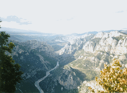
The Gorge du Verdon
The Ups and Downs en-route to Lyon.
After a rest day in La Salle sur Verdon, I cycled up the north side of the Gorge du Verdon (the opposite side to which I’d cycled two days previously). It was a magnificent day out, the wind had dropped and I was far more able to enjoy the scenery, steep sided cliffs and a road which really made you feel the canyon with every pedal turn. Upon reaching Castellaine, I left the Verdon and made an afternoon ascent of the Col des Leques, only a small pass with a pleasant descent down to Barreme, and another empty campsite. It was mid-September and the summer tourist season was definitely over.
I seemed to think that, once away from the high Alps and the correspondingly high passes, the route to Lyon, through Gap and Grenoble would not be very interesting. How wrong could I be! The passes were indeed lower, but the rugged scenery, the quiet narrow roads and the sleepy traditional French villages more than made up for it. My last week of cycling was simply brilliant.
From Barreme, I passed through Digne Les Bain, and over the Col du Fanget, where I met 4 English cycle-tourists who lived local to my home town of Stoke-on-Trent. I had lunch with them and enjoyed exchanging stories. Since the passes were lower it was possible to climb several passes a day and by now the hot sun had returned. I was feeling fit and seemed to climb without any real difficulties. Gap was a lively place, but eager to press on to my campsite I didn’t spend too long there.
One of the best passes in this area, has to be the Col du Noyer, a steep climb along a road deemed "Dangereux" according to the Michelin map. The ascent went through many small hamlets which overlook the wide valley base (the easy way to Grenoble). The heat at the summit was intense, but this was soon forgotten as I looked into the distance and saw an amazing mountain ridge with a liberal snow covering. Simply fantastic!
I reached Valbonnais the same day. Valbonnais is near to the Parc des Ecrins mountains which I’d seen from the Col du Galibier a week previously. One feature of cycling in this part of France is that there are so many quiet roads and passes to choose from giving all manner of options. The only problem was judging how long a particular section would take to complete – due to the unpredictable nature of the terrain. For example, I’d originally intended to travel much further than Valbonnais, but would have been cycling late into the night to have reached my original target! However, the unpredictability made for some exciting days out.
By now I’d slipped into a finely tuned morning routine, most days I would just be setting off with my loaded bike as the sunshine just began to break through into the valley. Each day I would be feeling fresh in the knowledge that today would reveal some new places, roads, views I’d never seen before and I’d have the satisfaction of having explored a little more of the world.
The road to Grenoble was very hilly; but lunch by Lac Luitel underneath a cloudless sky made it worth the effort A long downhill saw me in the centre of Grenoble. A very interesting looking place, but on a sunny Saturday afternoon it was extremely busy with both pedestrians and motor traffic. I didn’t stay long, mainly because I still had quite a lot of work to do, however Grenoble does feature quite high on my list of places requiring further attention.
The additional work that day involved cycling into the Massif de la Chartreuse, reaching St. Pierre de Chartreuse around dusk. I was in my element, every day seemed fantastic – even after 7weeks the novelty had still not worn off.
After leaving St. Pierre de Chartreuse, the summit of the first pass, the Col du Cruchon, turned out to be a checkpoint for a local cycle race. Despite not being a competitor (or more importantly paid the entry fee), I was made very welcome by the marshalls who gave me some food and drink – it was a pleasant exchange on an equally pleasant Sunday morning.
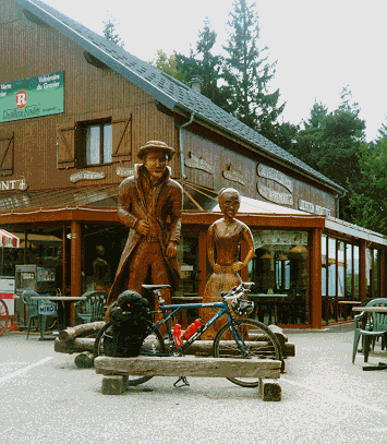
My bike is guarded by two wooden figures on the Col du Grangier
The descent from the Col du Grangier marked a return to the Savoie region and a visit to Chambery, a nice place, with large pedestrianised areas, broad squares and many old and interesting buildings. A hot afternoon and early evening were spent climbing "Le Revard". Unfortunately the views over Aix Les Bains were disappointing, I arrived too late and the sun was already setting, casting large shadows over the thermal town and its associated lake.
No sign of life at the campsite in Aix Les Bains, meant I was fortunate enough to have a free night’s camping! My penultimate day saw me camping in a small town called Champdor near to Hauteville Lompnes, climbing over the Col de la Rochette en route. I was now well and truly away from the high Alpine mountains, but the many ups and downs in this lower countryside still made for some demanding cycling.
"Le Revard"
Leaving Champdor bound for Lyon was a little sad. I knew I had to make this a good day, since tomorrow I would be home and the journey I had spent months planning would be complete. Two passes Col de la Berche and Col du Cendrier were ascended with relative ease. However, there was to be one further col worthy of a mention, the Col du Portes acted as a suitable finale. At 1010m it wasn’t a particularly high pass, but a decent downhill propelled me towards Lyon.
The medieval town of Cremieu provided an interesting stop-off point before navigating the minor roads leading to St. Quentin and my luxurious home for the night – a pre-booked "FORMULE 1" hotel. I arrived at 7:30pm, just beating the sunset. The hotelier made my bike more than welcome – imagine pushing a bike into a hotel reception in England, especially when the cyclist is covered in sweat and grime. The receptionist simply gave me a ground floor room so that I didn’t have to carry my bike up any stairs – hospitality at its best!
The mountains and climbs were over, however it had been the adventure of a lifetime. I was fit, sun-tanned, healthy, happy and content. The yearning to continue was strong, but I knew it had to end sometime. I’ll most certainly be back.
Technical Details:
I used a 1995 GT Pantera, fitted with road-tyres. My only problems were one puncture, a broken gear shifter (which was replaced in France), and a second-set of brake-blocks, required after 1200miles.
Packing Details:
I travelled as light as possible, taking the absolute minimum in terms of clothing. My load was greatly increased by taking full camping kit including: tent, sleeping bag, thermarest and stove. All my items were carried in one set of rear panniers with a 45l capacity. My tent, however, was strapped across the top.