(only part of it, to be true: Cabo de Gata, Sierra de Gádor, las Alpujarras, Sierra Nevada, Granada, Guadix, Sierra de los Filabres, Karst en Yeso de Sorbas)
By Ralf Lehmann
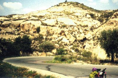
Monday, 3rd of April, 1995. Agua Amarga--Sierra de Gádor (119 km)
Leaving Agua Amarga, where I had arrived on a bicycle bus the evening before, on a paved road in northwestern direction. After 5 km I turn left onto a gravel road passing by an old windmill.
At Fernán Pérez I hit another paved road leading me to the south into the Cabo de Gata Nature Park.
Nice view on the sea from el Mirador de la Amatista. San José. After a break on the beautiful beach of Mónsul I cycle on using a gravel road
forbidden and barred for motor vehicles. At the end of a short climb magnificent views from the Cabo de Gata.
From here I go on paved roads to Almería, then further to the north and then west in the
direction to the Sierra de Gádor--a mistake, as there seem to be no hotels.
At dawn I unfold my sleeping bag at some distance to the highway under the open sky.
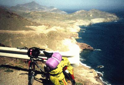 View from the Cabo de Gata
Tuesday, 4th of April. Sierra de Gádor--Laujar (50 km)
The night is a bit cold and windy and I wake up frequently in my thin sleeping bag, thus having the opportunity
to watch Orion move across the sky in the first half of the night.
At sunrise I get up and move on.
I shop some food in Alhama and rest on a scenic platform nearby.
Canjáyar and other white villages in arabic (Berber) style: the houses are whitewashed cubes built closely to each
other, the flat roofs are covered with fine grey impermeable
sand. New houses are built in the same style.
The highway mostly goes uphill as I am entering the Alpujarras.
I find a hotel room in Laujar (capital of the Alpujarras, alt. 921 m).

Village in arabic style
Wednesday, 5th of April. Laujar--Bérchules (52 km)
Uphill and downhill sections in a beautiful landscape on the south slope of the Sierra Nevada with more white villages.
Great views.
After Ugíjar a 63-year-old mountain biker starts a roadside conversation on bicycling, this year's draught and possible climate change.
Unlike me, he believes the Puerto de la Ragua is the only pass crossing the Sierra Nevada. (I intend to use a different pass within the next days.)
In Bérchules I spend the night not in the hotel beside the highway, but in the Bar-café-camas-comidas
in the middle of the village. From the room I have access to the flat roof with a view on Bérchules, the neighbouring village of Cádiar and the Sierra de la Contraviesa in the south.
Thursday, 6th of April. Bérchules--Capileira (43 km)
Uphill in the direction of Trevélez. A pass, unlike many other passes in Spain, has a sign giving its name: Portichuelo de Castargas.
Trevélez: highest village on the Iberian peninsula (altitude 1470 to some 1700 m).
I have some of the Jamón Serrano which they make here and visit the village as a pedestrian.
Later I take another rest at a mineral water spring near Pórtugos. The water is red and tastes like iron.
In the afternoon I go up the steep road to Capileira where I find a
hotel room.
Friday, 7th of April. Capileira (0 km)
Rest Day. (I need it !)
Saturday, 8th of April. Capileira--Granada on the carretera más alta de Europa (Highest Road of Europe) (84 km)
First I go uphill on six kilometers of paved road marked 'dead end street' and 'closed due to snow', then a gravel road starts with a sign 'do not enter',
then another sign '32 km of unpaved road, recommended for all-terrain vehicles' (all in Spanish, of course). In spite of the signs I feel confident enough to go on uphill.
At first the road goes through pine forest, then in greater altitude, beyond the tree boundary, there is a lawn-like vegetation.
I have a look at Trevélez (the highest village) from a marked viewpoint far above it. The other way I can see the Mulhacén (highest mountain
of Spain, 3481 m) and the Pico de Veleta (3392 m), the summits of both of them covered with snow. The road is visible from
quite a distance due to a white strip of snow on its mountain side. It goes north along the southwestern slope of
the Mulhacén, then turns west on the southern slope of the Veleta. Here, at over 2800 meters of altitude, there are bizarre rocks and no more plants.
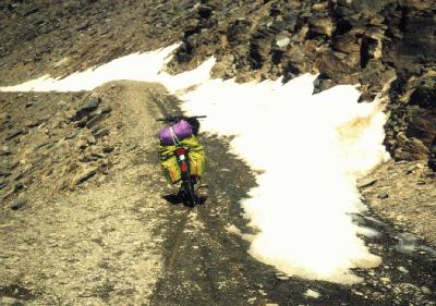
Cars cannot go beyond a certain point because the road (wide as a narrow car and having no guard rails) is half covered with snow in some places. I meet four cyclists coming downhill the other way and a dozen of hikers. Otherwise there is nobody. There is no cattle and there are no houses except the Refugio de Félix Méndez at approx. 3000 meters of altitude. The final climb is totally covered with snow, so I push the bike up to the Veleta Pass (Puerto de Veleta) at 3250 meters of altitude. This is the highest point of this trip; I do not dare to go up to the summit of the Veleta on another snow-covered road because it is already 6 pm. I roll down the northern slope of the Sierra Nevada, past the
radio telescope of the IRAM and down to Granada on a paved highway. The crowded city streets of Granada are quite a contrast to the mountain solitude experienced until an hour ago. At the third attempt I manage to find a hotel room for me and a garage for my bike. As I am at some 4 degrees western latitude and the clocks are adjusted to Central European Daylight Saving Time (corresponding to 30 degrees eastern latitude), there is still daylight at 8 pm, when I finally take a shower. Dinner time starts at 9 pm in Spain, so I am right on time.
Narrow point of the highest road of Europe

Rocky ridge
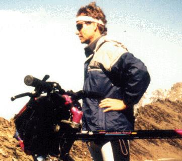
This is me at 3000 m of altitude

My bike on the Veleta pass at 3250 m of altitude
Sunday, 9th of April. Granada (0 km)
'Rest day' with a lot of walking and sightseeing. From the platform on the Albaicin in front of San Nicolas I see the Alhambra, the Pico de Veleta and the radio telescope (I can actually see when it is moved).
In the city there are pre-easter processions: Saints' figures are carried through the streets, masked penitents and bands marching behind.
Monday, 10th of April. Granada--Guadix (65 km)
I chose a small, partially unpaved road with little traffic to the east via Quéntar and La Peza. Near the
Quéntar reservoir a sign warns me: 'Do not enter, rocks being blown up with explosives'. I ask a local man after the way to La Peza; he indicates the barred road. I have to carry the bike over a big pile of rocks being moved by dredgers. A car could never get through here. Later I see workmen drill holes in big rocks to be filled with explosives. Evidently a wider and less winding highway is being built. After a long and very dusty uphill road section I hit pavement again and go downhill to La Peza. Here, at a junction, I decide to turn left in the direction given by a sign to Granada and Guadix. I go through forest, get a panoramic view from a platform and end up at a motorway entrance! The turn I made was wrong. Any legal way to Guadix from here would be a long detour, so I enter the motorway, go downhill and leave it at the second exit. (Warning: Don't do this at home! In Germany you would attract a dozen of police cars and get a lot of trouble. In this case there were only two or three motor vehicles on the new Autopista and I got away evidently unnoticed.)
I find a hotel room in the center of Guadix. Later I do a walking sightseeing of the baroque cathedral, palaces, houses, Plaza de la Constitución, arabic castle and the famous cave dwellings.
Tuesday, 11th of April. Guadix--Los Navarros (85 km)
Going east, shopping food in Alcudia. Against the wind across a high (alt. 1100 m) plain on the N324. Closely passing trucks expose me to dangerous turbulences. Therefore I turn left in order to find roads parallel to the N324.
I proceed on agricultural gravel roads and in a dry river bed.
The plain has evidently been overexploited agriculturally: there are dry irrigation trenches, deserted farm houses, dry fields and no persons.
Only at the eastern end of the plain I find people working on an irrigated plantation of almond trees, a type of agriculture notorious for destroying farmland on the long run.
From Huéneja on I use the N324 again; it is now going downhill.
This is the only 'rainy' day on this tour: a slight drizzle hardly manages to make me wet.
In the nice village of Gérgal the only hotel is shut down; therefore I go back to the junction at Los Navarros where there is a hotel.
Wednesday, 12th of April. Los Navarros--Tabernas (86 km)
In the morning
I see a white hemispherical building on top of the Sierra de los Filabres to the north. Spontaneously I decide to have a look at it.
On a steep paved road I cycle all the way up to the Calar Alto astronomical observatory at 2168 meters of altitude. There are several telescopes; I learn they can be visited in the early morning.
I cycle east on an unpaved road
on the mountain ridge offering breathtaking views to the north and south. Later I go downhill on a vertiginously steep and curved road with very coarse gravel. Hotel in Tabernas.
Thursday, 13th of April. Tabernas--Venta del Pobre (95 km)
Going northeast on the N340. Due to yesterday's escapade I missed part of El Desierto, the famous desert with film studios (Mini Hollywood).
Anyway, alongside the highway there is a kind of sandy desert with flowers scattered over it.
Right turn to a scenic easy highway across the Sierra de Alhamilla (also part of the desert).
Níjar: tourist town with many stores selling arts and crafts.
Campohermoso, Fernán Pérez. Left turn to go to Agua Amarga on the gravel road of the first day.
In the beautiful seaside resort/fishermen's village of Agua Amarga there is no accomodation available due to the easter holidays. So I change my plans and go straight away from the coast to spend the night in a motel in Venta del Pobre.
Good Friday, 14th of April. Venta del Pobre--Mojácar (61 km)
Past a group of palm trees looking like an oasis I cycle north on minor highways and enter a landscape called Karst en Yeso de Sorbas (Karst in the limestone of Sorbas).
At noon I stop in the center of Sorbas, a town on top of a limestone rock.
There are many local people waiting on the plaza and I simply join them.
Finally, a statue of St. Mary is carried out of the church followed by a band. The same happens with a Christ statue and a pietà.
A lot of masked penitents walk behind the statues.
Turre: hotels are closed. In Mojácar, a tourist town on a hill near the sea, I can only find a room in a ***luxury hotel.
Mojácar is a nice town crowded by tourists, but not half as beautiful as the villages I have seen in the Alpujarras where there were very few tourists.
Karst en Yeso de Sorbas
Saturday, 15th of April. Mojácar--Agua Amarga (34 km)
Coastal highway along beaches. One climb, easy for me due to the training of the past two weeks. Carboneras, Agua Amarga.
The departure of the bicycle bus is at 8 pm.
Total distance: 774 km.
Conclusions and Tips
- There are different ways to transport you and your bike to Andalucía. I prefer 'Bike&Bus'--this can be a very convenient, comfortable, ecological and inexpensive way to get you and your bike safely to a distant destination--if there is a bus going to your destination at the right time!
If your travel starts in Germany, you can visit these pages for a Bike&Bus schedule; there are also bicycle buses starting from the Netherlands.
- Spain is a mountain country -- therefore you should have some training.
- Winter and spring seem to be the best time for a trip in southern Spain. Crossing the Veleta pass is probably impossible in winter.
- Prices for accomodations and restaurants started at 1000 pesetas for accomodation, 1000 pesetas for a 'simple' 3-dish-and-wine dinner, 2000 pesetas for half board (dinner, bed and breakfast). Half board was some 7500 pesetas in the luxury hotel. (100 pesetas were between 1.20 and 1.25 DM, and are fixed to be be 0.601 Euros.)
- There are more inexpensive hotels than campgrounds.
- If you stay away from the sea and touristic cities like Granada you will not meet many tourists.
- I strongly recommend to learn some Spanish.
- It is possible to go up to the summit of the Mulhacén from the turn I mentioned; this is an off-road adventure partially on loose rocks (or very rough gravel, whichever way you look at it).
- For the crossing of the Veleta pass I feel it is a good idea to spend the night in the Refugio de Félix Méndez. (I regret I have not done this!) If you do so, you have the chance to cycle or walk up to the summit of the Pico de Veleta and maybe watch the sun set or rise from there!
Contact the author
