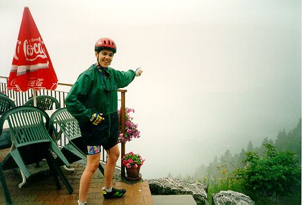
The best view in the Alps (Not)
We'd managed just one ride before getting to Bourg d'Oisans. This, around Annecy, included the Col de la Forclaz, claimed by a local friend to feature "the best view in the Alps" from the top. We were sadly unable to confirm this, as it was pouring with rain and visibility was down to 20 yards when we got there. A bunch of people in the cafe seemed very amused by us taking photographs of each other in front of a fog bank.
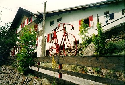
Our first ride out from Bourg d'Oisans was up the valley of the river Veneon, towards La Berarde. A couple of miles up this road, there is a hotel that apparently specialises in accommodation for cyclists, advertising this fact with several old bikes attached to the top of its front wall. Unsurprisingly, there was a Dutch flag hanging out of one window along with the selection of drying shorts.
This was a pleasant ride, climbing about 1000M in 17Km, with several sections at 10%, rugged scenery which included the back view of the ski station of les Deux Alpes, and a couple of good-sized waterfalls within feet of the road. On the way back down the valley, we stopped for lunch at the bar in St Christophe, where we were served a superb omelette. La Patronne was very complimentary about Thea's achievement in reaching her establishment, female cyclists clearly being a bit of a rarity in those parts.
The route of the Marmotte is basically a big loop. You start by climbing the Col de la Croix de Fer, and descending into the adjacent valley. You ride a little way up this valley, then cross back over the Telegraphe and Galibier. You then descend to Bourg d'Oisans (150Km, with 3,200M vertical), where you can stop and get the "Marmotton" award. True randonneurs, however, proceed from here up the Alpe d'Huez road to Huez, before another descent and a final climb to the finish at Vaujany after 180Km and another 1,400M of climb. I was only aiming to do the Marmotton, which seemed like a pretty stiff challenge itself, based on my largely non-existent preparation.
On the way back from the registration for the event, which was rather inconveniently located in Vaujany, we drove along part of the full Marmotte route from Villard-Reculas to Huez. This road was marked on the map as being "dangereux". A more accurate description would have been "suicidal", as it was only wide enough for one car, half-heartedly surfaced, and carved along the top of a sheer 700 metre cliff, with no crash barriers. I felt dizzy and nervous driving along it, and glad that I wouldn't have to cycle it the following day.
On the Sunday morning, Thea drove me to the start at the foot of the Croix de Fer, at 7.30am. It was fairly cold, but the skies were clear. After having checked out the registrations on the cars at our campsite, I was not surprised to see that there was a large contingent of Dutch riders, but I also spotted a couple of British club vests. As I was a late entrant, it was not until 10 minutes after the official start that I actually crossed the line, and headed off.
The Croix de Fer isn't particularly difficult, as there are only a couple of fairly short steep bits in the 25Km it takes to get to the top. Apparently, these are the result of a major re-routing of the road caused by a landslide. I had been slowly losing places all the way up, but I felt better for the last couple of miles and regained some lost ground. I reached the Col after about two hours, refilled my bottles and ate a banana amongst the detritus of a couple of thousand hungry cyclists. The descent was pretty tricky, as the road is narrow and poorly surfaced. It took me about an hour to get down the other side to St Jean de Maurienne, and the temperature was already in the 80s when I got there. I'd passed quite a few brown-shorted puncture victims on the way, but survived without incident.
I rode the ten miles up the valley to St Michel de Maurienne mostly alone, having failed to stay with a couple of groups that had passed me, which with hindsight was the first warning of trouble to come. I refilled my bottles again at the fountain at the foot of the Telegraphe. By now the sun was well up, and I was really beginning to suffer. I had to stop several times on the climb to get some shelter. Little knots of cyclists gathered under every available piece of shade. By the time I got to the top, I was very hot, tired, on the verge of a major bonk, and really looking forward to the feeding station, which was supposed to be in Valloire, in the valley between the Telegraphe and Galibier. So, I was suffering a complete sense of humour failure when I eventually found the feed a couple of kilometres up the Galibier road out of Valloire.
I wolfed down a lot of nuts and the fresh and dried fruit that was on offer. There was a team of people cutting up oranges into a vast pile that was being just as quickly demolished by desperate cyclists. I could have done with a long rest, but there was no shade whatsoever, and the temperature was now well into the 90s.
I set off up the awesome Galibier, and was soon in worse trouble. I had eaten too much too quickly, and felt sick rather than revitalised. I needed more frequent, and longer stops. About half way up, at Plan Lachat, feeling worse than ever, I reached the cafe and could see the road going up a much steeper section on the opposite side of the valley. I knew that I couldn't get up it, and stopped at the cafe to await the broom wagon.
The first bus was full, so it eventually took over two hours to get a lift for the remaining 8Km to the top. One of my companions in the bus was a Dutch guy on his third Marmotte. He had punctured and crashed at speed going down the Croix de Fer, and the mobile first aid team had stitched deep cuts in his hip, knee and elbow. With great courage, he had managed to continue, and rode up the Telegraphe before deciding that he couldn't go further than the feeding station.
I rode back to Bourg d'Oisans from the top of the Galibier, which is 48Km, mostly downhill. Thea had given up waiting for me at the finish, and had retired to the campsite. She said she knew something was wrong when a couple from Southend finished on a tandem, and I still hadn't arrived !
I think I was defeated by a combination of lack of preparation, eating wrongly, and the heat. I had been feeling OK at the top of the Croix de Fer, but was in difficulty as soon as I started the Telegraphe, which had only entailed a short ride from the bottom of the Croix de Fer. If I were going to try it again, I'd want to start with a lot more climbing in my legs. I'd also take more food, and eat more on the way. Although I had a 36x28 bottom gear, I could have used something lower. Many of our Dutch neighbours in the campsite had successfully completed the whole event, although one had collapsed about 2Km from the finish, and was unable to continue.
I needed a day off after the Marmotte, so we drove rather than rode up the Lauteret, with a side trip up the Telepherique from La Grave to the Girose glacier at 3,200M. It was a clear day, with fine views towards the Mont Blanc range a long way north.
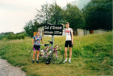
The next day, we went for a ride up the Col d'Ornon and back. This is an easy 500M climb from near Bourg d'Oisans. There is a possible loop ride over this col and back over the D114 a little further west, but we stuck to the easy out and back option. Near the col, there was a group of German cyclists who had left the road and taken on a little bit of cyclo-cross in order to take pictures with their bikes in the snow that was still left in the darker hollows of the mountainside.
A few days later, we rode up Alpe d'Huez on the morning before the Tour arrived. If you're going to climb the Alpe, this is the time to do it. We'd been woken early by the sound of vehicles going up the mountain, and on setting out, found "Der Teufel", the (in)famous German tour follower parked opposite our campsite entrance, at the foot of the climb.
The atmosphere on the climb was terrific. Breakfast-eating spectators lined the road, offering encouragement, and several offered Thea (but not me) some food. I didn't find it particularly difficult, because although there are a couple of 10% stretches, the 21 hairpins are wide and flat which gives a little respite, the road surface is excellent, and I wasn't trying very hard. It was also early in the morning, so the temperature was comfortable. I reached the ski station in 75 minutes, merely twice as long as it later took Marco Pantani at the end of a seriously hard stage. Thea was a few minutes behind me, and we managed to miss each other in the crowds, so we ended up riding back down individually.