Contents: Tours (131) Trails (7) Cycling info pages (2) Organizations and clubs (1)
Pages: Previous 1-40 41-80 81-120 121-141
America (local)
This page lists all reports that for America only that do not involve other countries.
Click here for a list of all reports involving America.
All descriptions are in English, unless otherwise noted.
Tours (continued)
| Rails-to-Trails Touring in America's Midwest
tour started September 2004, submitted 21 January 2006 America: USA
Trail reports and best strategy for touring 4 of America's longest Rails-Trails conversions that take you cycling through America's rural heartland on former railroad beds, converted to car-free bike trails, with comfortable, affordable motels a day's ride apart. Day-by-day, these reports describe how I cycled each trail plus loads of info and advice for anyone wishing to cycle the same route. The trails are: Root River Trail, 60 paved miles (100 kms) along Minnesota's beautiful Root River, 2 days, McElroy-Sparta, 105-mile (170kms) trail system along Mississippi River in Wisconsin, smooth-unpaved, 4 days (can be combined with Root River Trail), Mickelson Trail, 109-miles(175kms)on smooth, unpaved trail through historic, Gold Rush country of South Dakota's Black Hills, 3-4 days. The 225-mile (362-km) Katy Trail along the Missouri River in Missouri, smooth-unpaved, 4-5 days. All are fairly level, easy rides through historic railroad towns and scenic countryside rich in Americana and wildlife. |
 |
| To and around Seward
tour started 2005, submitted 29 December 2005 America: USA
Pictures of my Alaska bike trip/honeymoon this summer. |
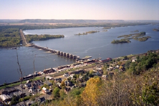
| Tour around Lake Pepin, 2000
tour started October 2000, submitted 24 December 2005 America: USA
In the fall of 2000, my wife and I planned a tour around Lake Pepin for our anniversary, starting and ending in St. Paul, Minnesota. A lovely short tour in easy stages- my first tour! |
 |
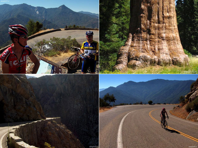
| Sequoia and Kings Canyon National Parks, CA: Cycling amongst immense mountains, deep canyons, and huge trees
tour started August 2005, submitted 25 October 2005 America: USA
Cycling Sequoia and Kings Canyon National Parks. 60 photos and movies by Steven Hill and Rebecca Heald. This past weekend, Rebecca and I participated in a really nice, informal, two-day bicycle tour through the Sequoia and Kings Canyon National Parks in the Sierra-Nevada, California. These parks protect some of the most stunning habitats you'll find anywhere. The huge elevational range (1,500' to 14,491') in this region features immense mountains including Mt. Whitney, the tallest mountain in the lower 48 states; huge trees including the General Sherman Sequoia Tree, the largest (by volume) living thing on earth and deep canyons including Kings Canyon which is deeper than the more famous Grand Canyon in Arizona. |
 |
| Oregon Cascade Mountains and Pacific Coast
tour started August 2004 America: USA
Although August is still considered high season, campgrounds are mostly completely empty. Campgrounds here are designed for RVs exclusively, and have RV hookups but no amenities beside a pit toilet and a well with a hand pump that dispenses wonderful cold water to fill my bottles. Well water is safe to drink; river or lake water is not. I normally want a hot shower in the morning and evening, so I got more and more desperate checking out one primitive campsite after another, until some friendly campers told me that the Lava Lake resort campground has showers and groceries. Although it's a RV campground, I highly recommend it - the sites are large and secluded, and the showers are great. Also, it has the first grocery store, or in fact any store, I have passed since Chemult. I am writing this sitting on the campground's boat pier, looking at the sun setting over the mountains all around me. |
 |
| Julien & Titus' Cycling Trip, 25000km in the Americas
tour started September 2003 |
| Napa Valley, Redwoods, Coast to San Francisco
tour started July 2002 America: USA
In the city of Napa, there is a friendly tourist info downtown on 1st. Stock up on food here because I haven't seen another grocery store for the rest of the day. I decided to take Silverado Road north, because unlike highway 29 it has a wide bike lane and is more scenic. There are beautiful vistas of vineyards and hills all the way. I was warned that both can be dangerous because the Napa valley is California's wine country, which means lots of drunk drivers, but I saw no evidence of that. I cut back to 29 on Bale St, and stayed in the Bothe-Napa State Park. One night costs $1 (like in all State Park campgrounds except the Bicentennial which was free), plus showers, and they never turn cyclists away. |
 |
| New England loop
tour started August 2001 America: USA
I spent the next day and a half in the White Mountains, which were the highlight of this tour. The main east-west road through the White Mountains is route 112, called the Kancamagus highway after an Indian chief. The first half of route 112 to Lincoln is mostly flat, but the second half is moderately steep at about 9%. There are only occasional views of the valley. The pass is about 600m higher than Conway, with a vista point. (Observed there: car stops, fat lady bounces out, leaving the motor running, regards the panorama for three seconds, emits a little squeal of delight, jumps back into the car and drives off.) |
 |
| Crater Lake to San Francisco
tour started August 1999 America: USA
Crater Lake is almost circular with a small island. There used to be a volcano there long ago, but its top blew off and left a very scenic lake. Due to its depth it is incredibly blue. In the summer (we rode in August) it is possible to ride around all around the lake; in the winter this road is closed. At the western side there is a mountain with a great view of the lake; the teaser image at the top of this page was taken there. Even in August there is snow there, and the path up the mountain is too rough to ride with road bikes. After a day at Crater Lake, we followed highway 62 towards Medford. The ride was an exhilarating downhill through dense forest, sometimes alongside lakes or white water rivers and creeks. The area is almost completely unpopulated, and there was suprisingly little traffic (this was on a Wednesday, I expect it would be worse on weekends). We stayed one night in a campground in the Valley of the Rogue, and continued the next morning to Medford. |
 |
| San Francisco to Los Angeles
tour started 1995 America: USA
Although Highway 1 closely follows the coast, which means constant postcard motives to the right, it is still hilly because the cliffs vary considerably in height. They are no problem for riding because none exceeds 250 meters, and most days we didn't have more than two of these. Of course, the downside to untouched beauty is that there aren't any grocery stores to stock up on water or bananas either. The Big Sur coast is not completely devoid of human civilisation. There are small ``towns'' like Lucia (population 3 according to the Bikecentennial map) and Gorda with grocery stores and restaurants, but they are few and far in between. Stock up on food whenevr you can, and you'll love the rugged untouched beauty of this section of the Pacific coast. The picture was taken in the town of Gorda. I once ate better fish-and-chips there than in London. |
 |
| Seattle to San Francisco
tour started August 1994 America: USA
Riding in Washington was easy. The roads mostly have wide shoulders and there wasn't much traffic. We had several tunnels, like the one shown in the picture. These tunnels had a button at the entrance for bicyclists to press that turns on flashing lights and warns motorists that there are bicycles in the tunnel and they might perhaps consider driving carefully. We were lucky and always had downhill tunnels, and didn't meet any logging trucks in a tunnel. A logging truck is a huge truck loaded with logs, and can be rather frightening when passing at high speed. They are more indigenous to Oregon though. |
 |
Trails
| Ride, hike and travel Lima-Miraflores and vicinity (Peru)
tour started May 2013, submitted 29 May 2013 America: Peru
South America tour:
As a bicycle traveler, I have been lucky to book a bike tour at the local organization bikingtoursoflima. Located at Miraflores. Not far from my hostel (Pirwa). Pirwa hostel is somehow better as rated and described at tripadvisor... So, the bike tour has been quickly organized. This time, I have been lucky. It worked! I have been supplied by a bike. You should know, Lima's roads are not made for bicyclists. They are wide, but the traffic is so heavy and car drivers are so 'nervous', that you may quickly will be run-over, once you show up on road. Most of the cross roads throughout the city, we have pedaled on sidewalks. No way - it seems to be a must! Once you reached the shoreline it is a very scenic place. The road follows the cliffs. Very nice. Right in the middle of Miraflores there is a food mall located. With extreme high class restaurants. Worth to go! Some Peruvian Soles could be spent there... Remember, we are now nearly on sea level. The typical Peruvian elevations are over by now. But the cliffs makes you ride on rolling hills. As we hit just some of the suburban villages down South, as e.g. Barranca and Corrilleres it didn't exhaust us to much. In this area, you may not find any signs of Inca culture at all. Lima-Miraflores is a place, where the well-doing upper class people live. See impressions from the ride at the pages below! Enjoy the pictures. Good luck to our followers! |
 |
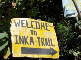
| Inca trail to Machu Picchu May 2013
tour started May 2013, submitted 27 May 2013 America: Peru
South America tour:
The tour starts at Cusco. The major capital city of the Incas. At Cusco you may find at least, if not thousands of travel agents who are offering the Inca trail tour and others. I have planned my tour in advance and... was cheated by an agent 'info@mapitrekperu.com'... Just $ 150,- which I have been asked to send via Western Union to Jenny Maribel Machacho Quispe at the address of Calle Hatun Rumiyonc Nr. 487, Cusco Peru. Emails bounce back, Telephone cannot be 'completed as dialed', their web-page does not exist anymore. But at Cusco I contacted the tourist police and they told me, this lady has many cases and is already ordered to court. I have therefore purchased a new tour at Coca travel agency at Cusco. Reliable! A 4days/3nights tour which has been a combination of biking and hiking to the Machu Picchu. [...] Without a tour guide, it wouldn't be wise to take the trail. For many reasons. Security is one, food and drink supply another. Check out the correct route another (not to found in a Coca jungle laboratory, whereas the 'shining path' protects the business). The hike up to the Machu Picchu ruins is not for mountain bikers as well. The path is so steep, that even young people give up and walk on the winding road up. But there the conflict with the never ending line of tourist buses start. The road is ruled by the bus drivers. Man, they can be rude. The road is narrow and they drive their way, no matter if a tourist is in their way... Sometimes scary. |
 |
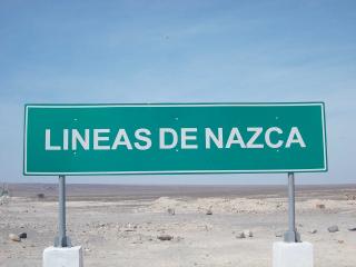
| hike (and bike...) to the Nazca Lines - May 2013
tour started May 2013, submitted 27 May 2013 America: Peru
South America tour:
I tried to book a bicycle tour, as I did on other locations at Bolivia and Peru... It has not been working out. The guys from bikeperu.com didn't find the time for a reply... No bicycle means automatically to find other means of transport - the car of the hostel keeper (Marco from Pirwa hostel Nazca). Nazca is a sort of rural place. It takes nearly 7 hours to go down by bus from Lima. You may meet people from all over the world. The way down to Nazca is on good paved road with wide shoulder. But there is low infrastructure in between. Let's assume you bike down on the Panamericana Sud, you have to plan your stay carefully in advance. It is a very dry, hot and sandy area. Never have seen a single bicyclist on the road. The high elevations are over...; nevertheless you may find 'rolling hills - a coastal road is never totally flat. The last part down to Nazca is 'inland' with some minor hills to climb in between. I have refused to fly over the lines. They have two steel structure platforms, whereas you may see a lot of lines. Figures etc. Most of the lines go back to 800 before Christ. They belong to the times before the modern Inca. [...] Enjoy the pictures. Good luck to our followers! |
 |
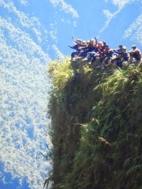
| The death road ride - Bolivien 2013
tour started May 2012, submitted 26 May 2013 America: Bolivia
Many times I have checked at the Internet this ride... Now, dreams has come true... The Death Road, or as it is called 'the most dangerous road of the world" is the ultimate downhill ride. People from all over the world doing this, and try to get a kick. I did it with the support of 'Gravity Biking'. A very reliable organization, which I really can recommend. They have experienced tour guides, who makes this ride easy and safe. Gravity Biking also provides the bike. We had blue sky weather, with some exceptions, e.g. when crossing a waterfall, or a misty jungle area. You should take into consideration, the start is elevated at a height of 4.700 meters, finally going down to 1.250 meters. Passing at least 3 climate zones. The road comprises a ride on paved road, round 13 kilometers and about 47 kilometers on dirt road. Hanging cliffs, makes the ride somehow scenic (...and dangerous). Today, not so many bikers die per year.... The original name came by the fact, that, before the new paved road, this road has been the connecting road to go from La Paz to Santa Cruz. Today, as the new road is completed, the old road became a mountain bike Eldorado. The organized tour ends with a zip line event. We found a three rope zip line - the flying fox (check out at the Internet!) Please note: when entering the lower part of the road, just before the paved roads ends, you are passing a local police check point. It may happen that even tourists are forced to undertake a drug test. Because this area is known as one of the Coca farming area. Coca leaves has two sides: one is the Coca leave tea, which is legal and a rather good medicine to overcome height sickness symptoms. The other side is the processing the Coca leaves in jungle laboratories and traffic the final product. They say, the "shining path" organization today comprises no more than 50 people which protect the Cocaine trafficking. |
 |
| cicloturismo y mountainbike en Pereira y Dosquebradas, Colombia
tour started January 2006, submitted 2 May 2006 America: Colombia
language: es
Bikerranqueros es una propuesta que busca motivar a todas las personas para que desempolven la bicicleta y salgan en su tiempo libre a recorrer los caminos de Pereira y Dosquebradas por medio de la práctica del cicloturismo y Mountain bike. |
 |
| Mountainbiking in California
tour started July 2004, submitted 21 February 2006 America: USA
In 2004 for we bet on biking in California, to search for some of the best singletrack, in places such as Annadel, Downieville, Truckee, Lake Tahoe and Monterey. Essentially, we did the same thing as the previous summer, when we cycled in Colorado, but in a different part of the United States. |
| Colorado Singletrack
tour started July 2003, submitted 21 February 2006 America: USA
2003 we biked in Colorado. The idea was to ride the famous Colorado singletrack, biking between the places with singletrack, to see whether the Colorado singletrack is the best in the world. The question remains unanswered as we have zillions of miles of singletrack to try yet. However, one thing is clear, Colorado singletrack is fantastic. Colorado has some of the best trails in the world. |
Cycling info pages
| Explore California's Santa Ana River Trail - A Bicycling Adventure
, submitted 30 June 2009 America: USA
The Santa Ana River Trail spans over 120 miles through Orange, Riverside and San Bernardino counties in Southern California. The trail is one of the largest non-motorized social boulevards in the United States. It is utilized by school kids, workers, walkers, runners, bicyclists, horse riders, bird watchers and its parks and open spaces are social gathering places for kids, families and communities. It is a favorite bicycling route in California. The Santa Ana Rover Trail is paved with handicap accessibility. Along the Trail there are parking areas, picnic tables, restrooms and local restaurants. Friends of the Santa Ana River Trail is a volunteer community group involved in trail safety education, eco-friendly preservation and recreational multi-use of the Santa Ana River Trail system. Also, known as the Santa Ana River Bikeway, Santa Ana Bicycle Path and SART. Our goal is to encourage a high quality, family oriented trail system that blends an attractive mix of recreational amenities, neighborhood green space, and local cultural heritage allowing people of all ages and abilities the pleasure of outdoor recreation in a fun and safe environment. As Santa Ana River Trail advocates our community oriented goal has three main parts: 1) to enhance public safety of the Santa Ana River Trail through public education and volunteer community watch; 2) to encourage the socio-economic recreational use of the Santa Ana River Trail as a conduit for connecting local communities, neighborhoods, families, friends and workplaces together; and 3) to act as the Santa Ana River Trail Mediator resolving trail use disputes, complaints, and injury. |
| Bicycle Shop finder - over 6,000 locations nationwide
, submitted 1 June 2006 America: USA
Finds bicycle shops by state and city, and shows their locations on a map. |
 |
Organizations and clubs
| Bicycle Club finder - over 2,000 locations nationwide
, submitted 1 June 2006 America: USA
Finds bicycle clubs by state and city, and shows their locations on a map. |
 |